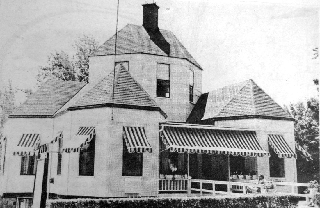
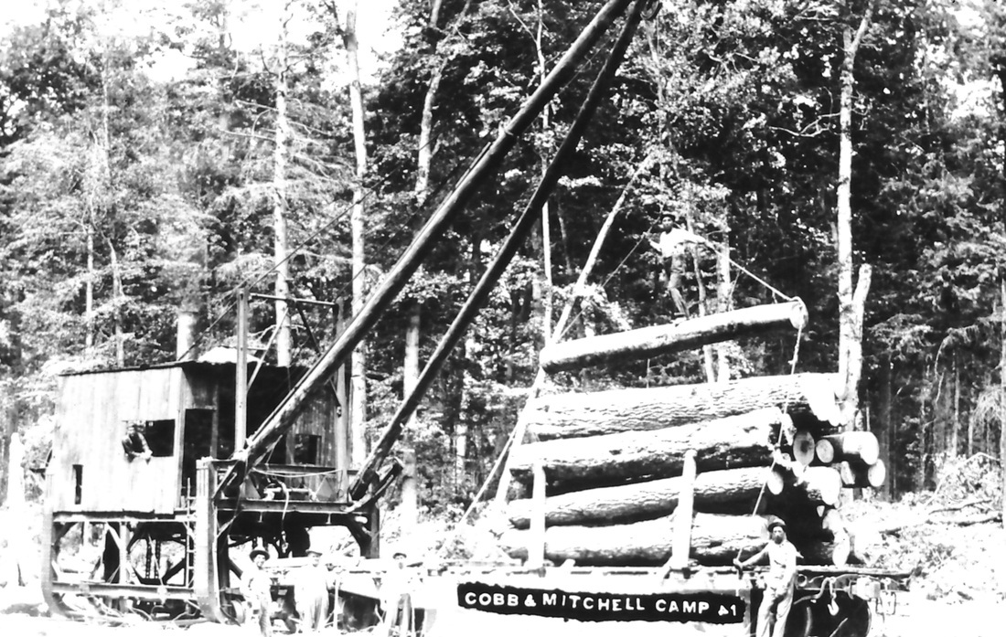
The photo above shows a hand embroidered square (by Marianne Arnold, granddaughter of Chandler Township residents Howard and Marion Mackie Wood) from the 1976 Bicentennial Quilt made by the community women of Chandler Township Charlevoix County Michigan. Each square represented one of the 36 sections of the the township with this particular square depicting the Cobbs & Mitchell Railroad which was such a prevalent piece of the very fabric of Chandler Township's history.
The design and compilation of the text and photos on this site are copyrighted 2013.
Most posted items will enlarge by "clicking" on them.
"Clicking" on some highlighted words may access additional information.
Please do not copy the photos on this site, many of which have been submitted by private individuals...
just come back and visit the site often to view the photos.
Most posted items will enlarge by "clicking" on them.
"Clicking" on some highlighted words may access additional information.
Please do not copy the photos on this site, many of which have been submitted by private individuals...
just come back and visit the site often to view the photos.
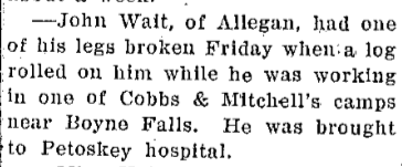
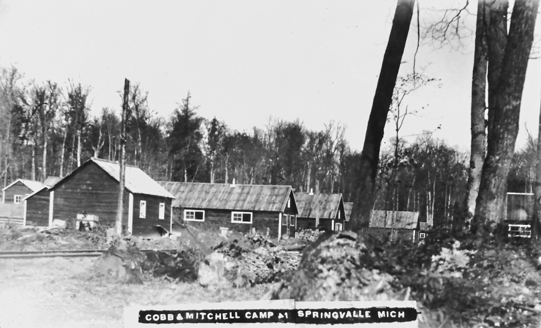
Chandler Township did not have the benefit of large rivers or streams as a waterway to move logs for the lumbering business. Railroads were needed to do the job of moving the logs and wood to market. Because huge land grants already had been made to encourage the Grand Rapids & Indiana Railroad to the North, in about 1899 the Cobbs & Mitchell Railroad extended a line from Boyne Falls into Chandler Township to their company town of Springvale... a lumbering town. The logging industry, and the railroad, brought a town with businesses, and more pioneers to Chandler Township. The following book told how the Chandler Township population of pioneers had increased through the years... only to dwindle again when the logging industry had died down, the railroad withdrew, and the town of Springvale disappeared, supposedly sold in 1926 for $400.00... to whom? Springvale had been settled for Cobbs & Mitchell Inc, a lumbering company and railroad, so Springvale's population vanished with the lumbering industry. In 2013 no signs of Springvale exist, except a slight indentation in the ground.
A History of Northern Michigan and Its People Volume 1
by Perry F. Powers, Harry Gardner Cutler,
published by The Lewis Publishing Company in 1912 stated:
Chandler Township population "shows continuous advance".
1890 ~ 144
1900 ~ 273
1910 ~ 397
by Perry F. Powers, Harry Gardner Cutler,
published by The Lewis Publishing Company in 1912 stated:
Chandler Township population "shows continuous advance".
1890 ~ 144
1900 ~ 273
1910 ~ 397
In 1905 the population of Springvale was about 50, and by 1910 the population of Springvale had grown to about 60; as compared to the 1900 and 1910 population records ( shown above) for the entire Chandler Township.
The 1921 Chamber of Commerce Map of Charlevoix Co. Michigan and Adjacent Territory Map (by E.A. Robinson of Boyne City MI) highlights the lumber company owned Cobbs & Mitchell Railroad as it leads right to Springvale MI in Chandler Township. The Cobbs & Mitchell spurs off from the Grand Rapids & Indiana Railroad (GR&I RR) in Boyne Valley Township's town of Boyne Falls MI. It was the Cobbs & Mitchell railroad line that owned and accommodated the lumber industry in Chandler Township, and serviced the village of Springvale.
The 1921 Chamber of Commerce Map of Charlevoix Co. Michigan and Adjacent Territory Map (by E.A. Robinson of Boyne City MI) highlights the lumber company owned Cobbs & Mitchell Railroad as it leads right to Springvale MI in Chandler Township. The Cobbs & Mitchell spurs off from the Grand Rapids & Indiana Railroad (GR&I RR) in Boyne Valley Township's town of Boyne Falls MI. It was the Cobbs & Mitchell railroad line that owned and accommodated the lumber industry in Chandler Township, and serviced the village of Springvale.
|
The growth of Chandler Township in Charlevoix County parallels that of Cadillac MI. Cadillac, like Chandler Township's nearby city of Petoskey, and the Village of Springvale, also has a MITCHELL STREET named after one of the owners of the Cobbs & Mitchell Railroad which finally made its way into the heavily forested Chandler Township to its company developed Village of Springvale. Cadillac's Official Website chronicles the beginnings of Cobbs & Mitchell on the scene in Michigan's northland, especially in Cadillac. William Mitchell of Indiana owned an interest in the G.R. & I. [Grand Rapids & Indiana Railroad]. The G.R. & I. gathered steam in about 1867, after having earned a grant to build a railroad from Grand Rapids to Mackinaw, thus running through Boyne Falls where Cobbs & Mitchell Inc. railroad was able to spur off to Springvale. William Mitchell's youngest son George A. Mitchell was a pioneer of exploration for the G.R. & I.'s proposed route to the north. George had been called a visionary who foresaw the needs of people, and thus the creation of the Village of Springvale, as the Cobbs & Mitchell Inc. railroad ventured into Chandler Township's timber area. George A. Mitchell actually became the first mayor of Cadillac MI after he had so carefully grown the town through its lumbering industry. It was at that time in 1874 that George Mitchell was able to inspire Jonathon W. Cobbs to begin working for an existing Cadillac area mill... the Cobbs & Mitchell Lumber Mill. That cooperation between Cobbs and Mitchell was felt enormously in Chandler Township as witnessed on the 1901 Chandler Township Plat Map where most of the land was owned by Cobbs & Mitchell. Perhaps Cobbs & Mitchell had known about the GR&I's own A Guide to the Health, Pleasure, Game and Fishing Resorts of Northern Michigan book, where the GR&I had placed the advertisement as seen here to the right. Most of that same land, once owned by GR&I, and next by Cobbs & Mitchell, is now owned by the State of Michigan, so explaining the 75 percent of Chandler Township being "state land" in 2013. Springvale existed because of the lumbering industry, and its accessibility made possible by the Cobbs and Mitchell Inc. railroad, which shipped the Chandler Township wood to Cadillac to the wood industries to manufacture products like wood flooring. So when the lumbering industry died down, and with no other industry to fill its void, the train stopped running, pulling up its tracks as it pulled out, and Springvale became a "Ghost Town"... no visible remains of the village exist in 2013, only some indentations in the earth.
|

1882 ~ Advertisement for Sale of Land from Grand Rapids & Indiana Railroad
|
A History of Northern Michigan and Its People Volume 1 published in 1912 explains (on pages 174-175) how the GR&I made it to Northern Michigan. That fete had to have been completed before spurs, or branches, like the Cobbs & Mitchell Inc. railroad running off into Springvale MI could come into being: "The Grand Rapids & Indiana main line runs from Fort Wayne, Indiana, to Mackinaw City, Michigan, a distance of over 366 miles. It passes through west of the central portions of Northern Michigan the western townships of Osceola county and the eastern of Wexford, where (at Cadillac) it sends off branches toward Lake Michigan on the northwest and Lake Erie on the far southeast; cuts through a southeastern corner of Grand Traverse county, with branches running northwest to the extremity of Leelanau county, on Lake Michigan; then passes through northwestern Kalkaska county and central Antrim into Charlevoix county; turns north to Petoskey, and thence northeast and north, through Emmet county, to Mackinaw City. The original survey of the Grand Rapids & Indiana trunk line was made in the late fifties, but the Civil war and other events and conditions detrimental to railroad construction delayed the actual building, so that nearly fifteen years passed before the line reached Reed City, or the Northern Michigan of this history. The engineer father of the road was General William P. Innes, of Grand Rapids, who died at his home in that city on August 2, 1893. He was born in New York City and came to Michigan, in 1853, as a civil engineer in the employ of the Detroit, Grand Haven & Milwaukee (then the Oakland & Ottawa) Railroad Company. He remained in the employ of that road until its completion, when he took charge of the Amboy & Lansing, then extending from Jonesville to Saginaw, and was with that road until 1861. In 1857 he made the preliminary survey for a road from Grand Rapids to Mackinaw, being the land grant road afterward merged into the Grand Rapids & Indiana Railroad. In the Civil war he was colonel of the Michigan regiment of engineers and mechanics and for a time was military superintendent of railroads of the department of the Cumberland In its extension northward the Grand Rapids and Indiana road reached Morley, Mecosta county, in October, 1869, and Big Rapids a year afterward. In the closing days of 1870 Reed City (the first station in our historical territory) was bound to the outside world through the iron horse, and thereafter progress was more rapid. Cadillac celebrated her advent into the list of railroad towns before the close of the year 1870 and in 1871 Traverse City followed. By the spring of 1874 Boyne Falls (a creature of the road) and Petoskey had been reached, and then, for some years the enterprise lagged, for the good reason that land titles were somewhat insecure in Emmet county, and the inland region from Petoskey to Mackinaw City was wilderness. The general settlement of the county and the development of its agricultural resources had been delayed by the fact that the lands of Emmet county were still subject to the Indian treaty. In August, 1874, the eastern tier of townships came into market, and April 15, 1 875, the remainder of the county was thrown open to actual settlers. At that time the white population of the county was about one hundred and fifty. As stated, the Grand Rapids & Indiana Railroad had just opened a highway of travel and transportation through the county, and the village of Petoskey had just entered upon its career. Upon putting a railroad through Northern Michigan the date named the books were opened at the United States Land Office at Traverse City, and so great was the rush for land that over eight hundred claims were entered during the first three days. Under an act of congress soldiers in the late war could homestead one hundred and seventy acres of land while a citizen could homestead only eighty acres; consequently the greater portion of the land was taken by soldiers who settled upon homesteads of one hundred and sixty acres."
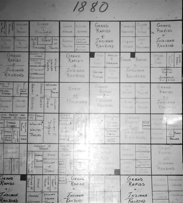
Hand drawn replica map of the 1880 Chandler Township Charlevoix County MI plat map
|
Judy Giganti and Micki Howard were in Lansing MI researching Chandler Township for the Nation's 1976 Bicentennial, when they came across an original 1880 plat map of Chandler Township Charlevoix County MI. They hand drew the 1880 replica map to the left, to use a copy of it in the "History of Chandler Township" video they produced for the Bicentennial. The map is important in Chandler Township's history because it lists the land in the sections of the township, many of which were owned by the Grand Rapids & Indiana Railroad [GR&I], BEFORE the Cobbs & Mitchell railroad came into Chandler Township. In 1880 the GR&I had not laid track into Chandler Township. They merely owned the land as labeled on the township plat map. It probably was not until the extension of Cobbs & Mitchell Railroad into its company Village of Springvale that railroad track was actually set. That happened as mentioned above when the GR&I investor from Indiana, William Mitchell's son George, began a working relationship with Johnathan Cobbs, eventually forming the Cobbs & Mitchell Inc. railroad which purchased the Chandler Township land, and then ran out to Springvale.
In the 1880's Phelps & Dodge [William E. Dodge] also were land developers, speculators, out of New York... and, had invested in several parcels of land in Northern MI. |
18 August 1880 ~ The Cass County Republican Dowagiac MI
Page Below: The GR&I "Donation to secure the construction of Cobbs & Mitchell's road east of Clarion.......... 2,902.67"
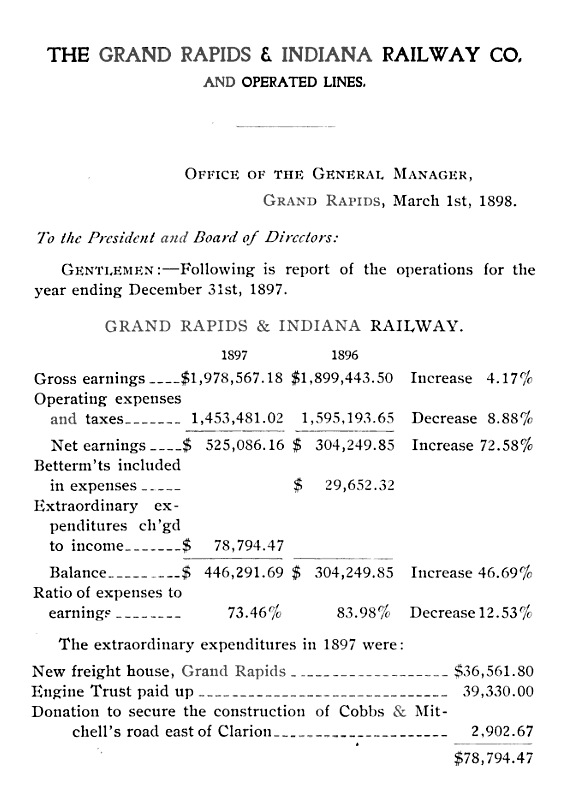
1897 Grand Rapids & Indiana Railway Company Annual Report
10 June 1904 ~ The Otsego County Herald Times
|

22 October 1904 ~ Charlevoix County Herald (an East Jordan newspaper)
|
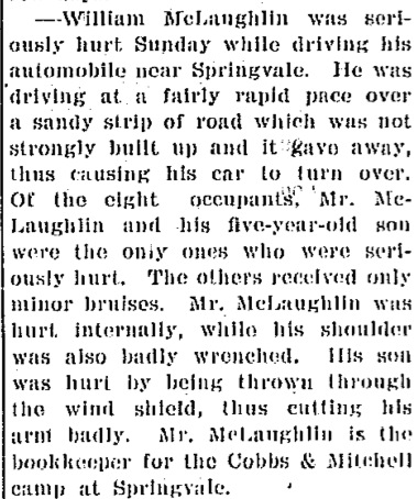
8 August 1910 ~ Petoskey Evening News
|

10 August 1910 ~ The Petoskey Record
|
|

Submitted from the Collection of Marilyn Mattox
|
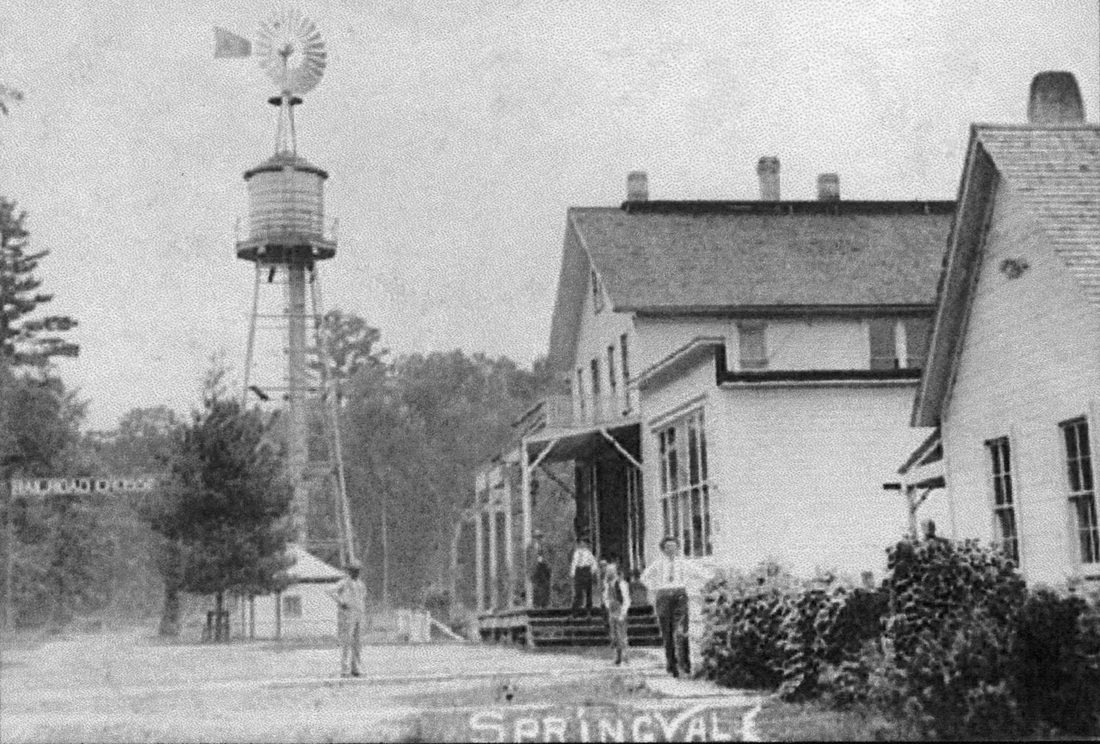
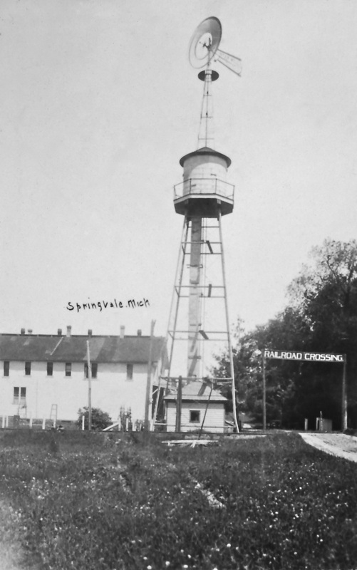
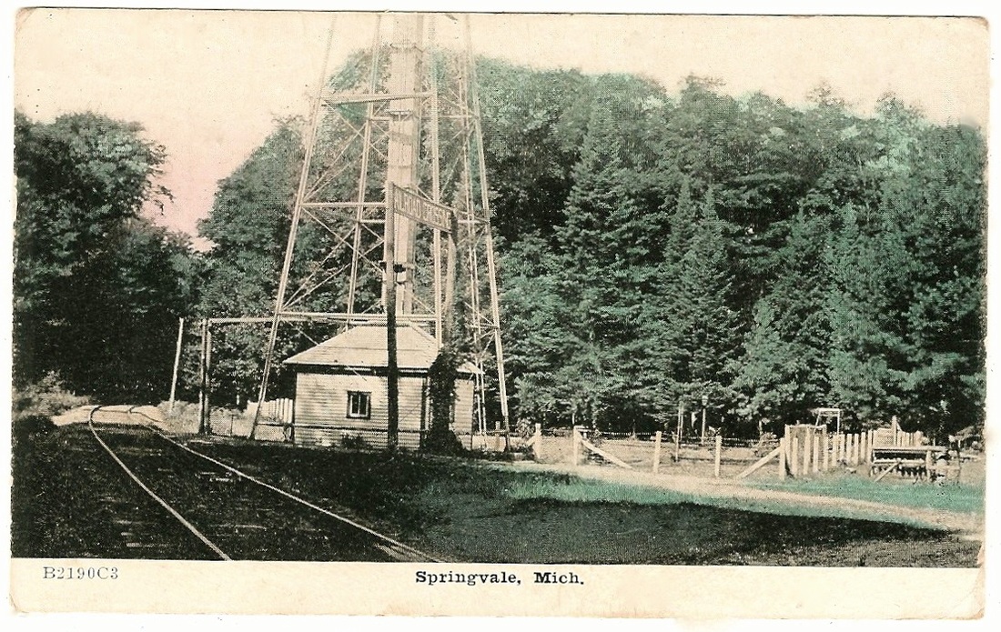
Springvale RAILROAD CROSSING sign hung over the roadway beside the water tower/windmill

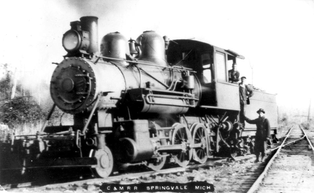
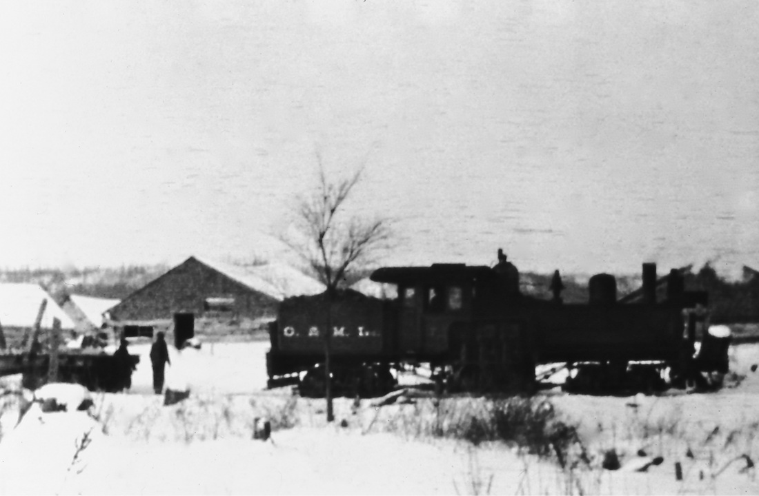
Boyne Falls & Northeastern Railroad #7 ~ Submitted by Wendy Butka from the Collection of Lila Magee
Boyne Falls & Northeastern
O: 015, 024 Private logging railroad Owned by Cobbs & Mitchell 8 miles, Boyne Falls to T34N R4W Built about 1898 |
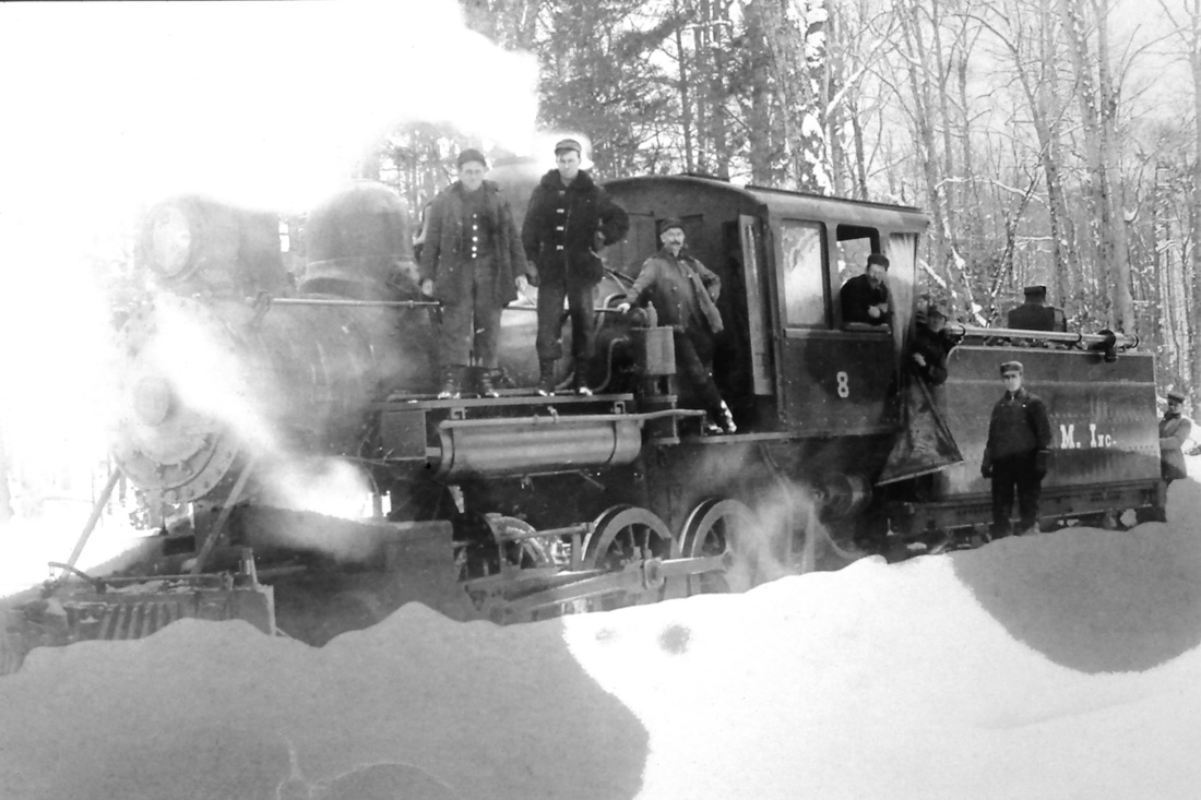
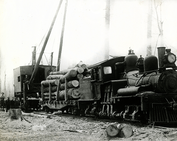
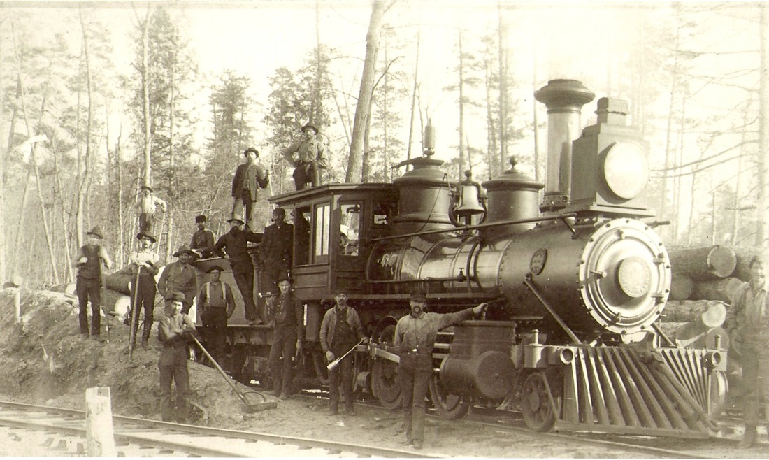
Cobbs & Mitchell Inc. Engine #8

Cobbs & Mitchell Inc. Engine #8 (Boyne Falls and Northeasten) ~ Collection of Charlie Conn
|
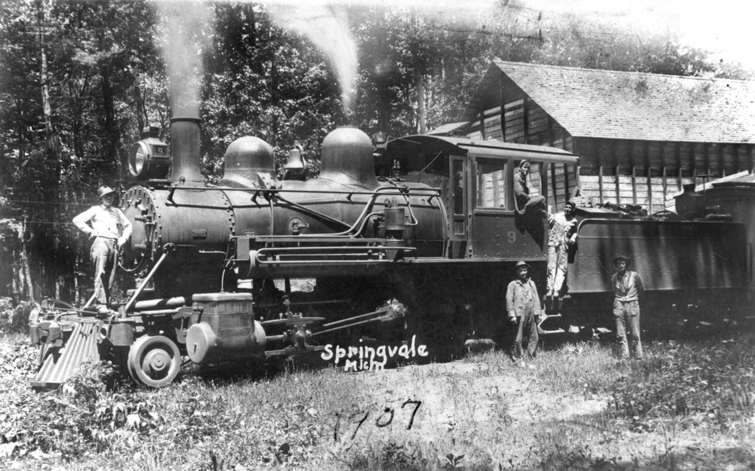
Another photo of Engine #9 is farther down this page. ~ Collection of Charlie Conn
|
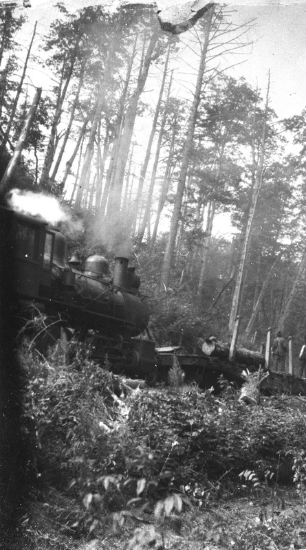
In Chandler Township, the Cobbs & Mitchell Railroad and the Village of Springvale, had a symbiotic relationship, and both existed only because of the vast lumbering industry of the area which required a railroad to transport the lumber products, and required a village, to provide for the people involved with the lumbering industry. This relationship meant that when the lumbering industry died down, the railroad, and Springvale village both ceased to exist. With the lumbering donw, the railroad withdrew... pulling out the track as it departed, and the town of Springvale eventually disappeared like the tracks of the railroad (see photo below), temporarily leaving behind an old building foundation, and a mounded railroad grade. Springvale had been settled for, and by, the Cobbs & Mitchell Lumbering Company, so Springvale's population vanished with the lumbering industry.
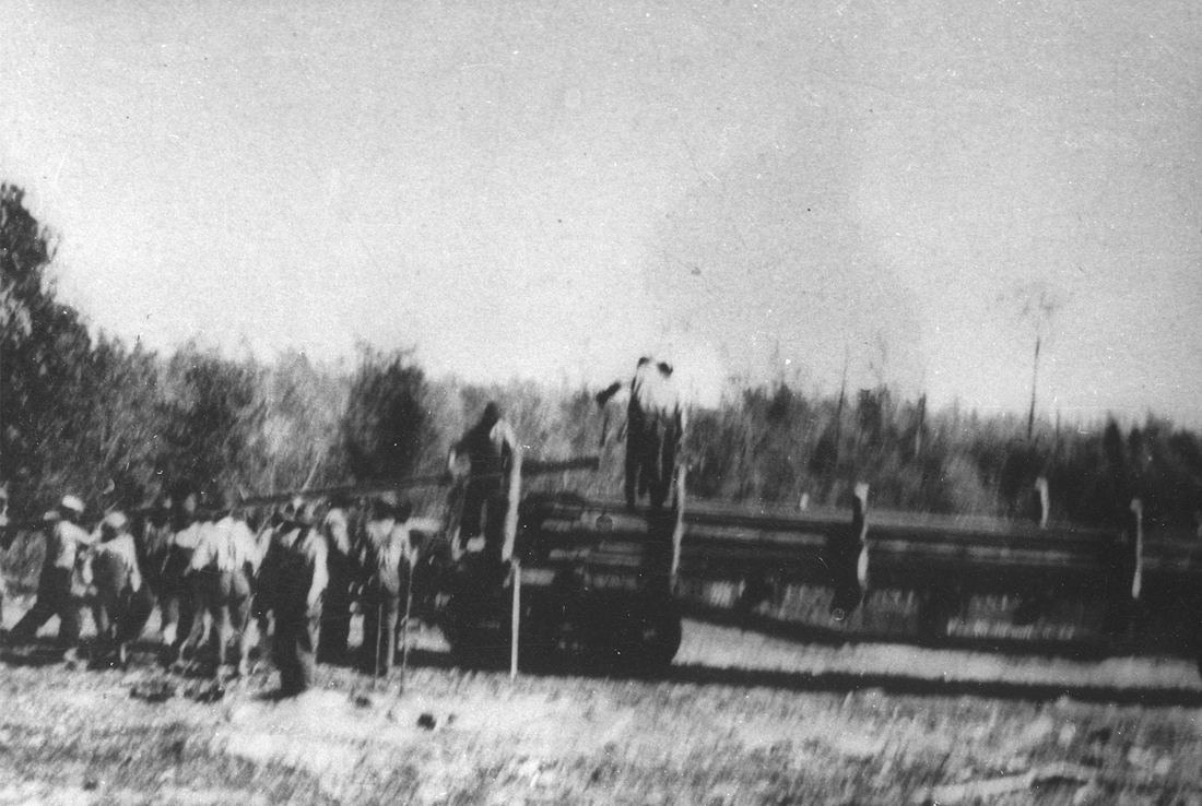
Cobbs & Mitchell Rail Removal ~ From the Photo Collection of Charlie Conn
Carl Bajema has a great interest in the logging railroads, and hiked most of the miles of the Cobbs & Mitchell "Boyne Falls & Northeastern Railroad" from Boyne Falls into the Springvale area. See the photo of Carl Bajema from the hike with the Hughes Cross in Dot. Carl Bajema stated: "A number of logging railroads had corporate names. I found a note that stated that Boyne Falls & Northeastern RR was incorporated in Michigan on May 26, 1899 and dissolution was recorded on May 10, 1937. Corporate names had a number of legal advantages for a logging railroad that built approximately 100 miles of track from Boyne Falls NE in Charlevoix county and all the way into southern Emmet County (Springvale twp) and into western Cheboygan county near Wolverine."
From the 24 May 1900 "Arena", an early Boyne Falls newspaper published by H.H. Eaton & son:
"Cobb and Mitchell are putting in a steam skidder somewhere up in the B.F. & N.E. Railroad. We have no idea what this is, but imagine it to be a gigantic iron man, something like the Colossus of Rhodes, that eats wood or coal and stalks about the woods under intelligent guidance, grabbing up handfuls of maple logs wherever they happen to be cut and piling them on cars or along the track as directed by the driver, who sits astride the giant's neck with a pikestaff precisely as a Hindoo manages an elephant."
"Cobb and Mitchell are putting in a steam skidder somewhere up in the B.F. & N.E. Railroad. We have no idea what this is, but imagine it to be a gigantic iron man, something like the Colossus of Rhodes, that eats wood or coal and stalks about the woods under intelligent guidance, grabbing up handfuls of maple logs wherever they happen to be cut and piling them on cars or along the track as directed by the driver, who sits astride the giant's neck with a pikestaff precisely as a Hindoo manages an elephant."
Once the wood was loaded onto the railroad cars, it was hauled to a particular industry for production, with much of the Springvale wood hauled to Cadillac MI to be prepared for the hard wood flooring markets. Cadillac was the home base for the Cobbs & Mitchell Inc. railroad. The 1912 State of Michigan book titled Wood-Using Industries of Michigan by Hu Maxwell, Expert, listed the many types of wood, and the various industries the particular wood could best be used.
Back of this old postcard had "Ward Mackie" written on it. Ward may be the first man on the left with his brother Pete Mackie being the third man in from the left.
|
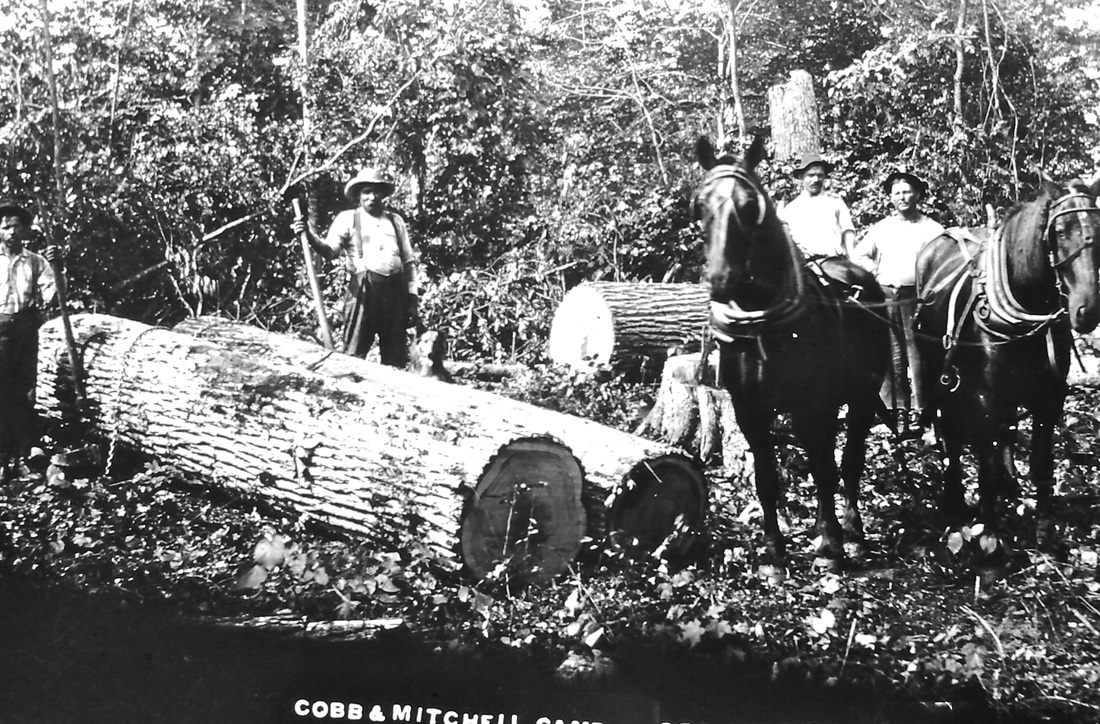
Photo Below: Behind the horses and laborers is a flat car
with board railings... holding pieces of wood. 
Back of Postcard had "Earl Hughes" written on it.
Earl Hughes was listed on the 1910 Chandler Township Census Records as born about 1891 in Michigan, with his wife Bertha. His occupation was listed as "Teamster Lumber Camp".
|
Last Logging Operations At Springvale with Skop As Engineer (Shay Engine)
Cobbs & Mitchell Inc. railroad was an offshoot of the GR&I [Grand Rapids & Indiana Railroad]. So, it was only after the time of the initial appearance of the GR&I into Northern Michigan, that lumbering lines, like Cobbs & Michell's railroad, could spur off the main GR&I. As stated in A History of Northern Michigan and Its People Volume 1 on pages 174/175, "By the spring of 1874 Boyne Falls (a creature of the road) and Petoskey had been reached, and then, for some years the enterprise lagged, for the reason that land titles were somewhat insecure in Emmet county, and the inland region from Petoskey to Mackinaw City was wilderness."
Facilities For Turning Cobbs & Mitchell Engines Necessary
The following information and photo are from "The James Winslow Collection" and are posted here
with Mr. Winslow's permission, strictly for viewing.
Please do not copy.
The following information and photo are from "The James Winslow Collection" and are posted here
with Mr. Winslow's permission, strictly for viewing.
Please do not copy.
Jim Winslow wrote: "I don't keep records on the small spurs in connection with GR&I [Grand Rapids & Indiana Railroad] such as at Boyne Falls for Cobbs & Mitchell. They were put in to log off specific tracts of timber. When the timber was exhausted, they tore up the spur and moved to the next parcel. Cobbs & Mitchell had a number of such spurs. Closer to your home territory, there was one east out of Clarion area for example.
However, I did glean a little info on the line to Springvale from Boyne Falls from the GR&I mention in their Annual Reports, and have attached a photo [below] from my collection which states on the back 'Cobb & Mitchell near Boyne Falls' (No date). The Annual report for 1899 states in part 'The turntable at South Yards [Grand Rapids] being too light to handle heavy engines with promptness and economy, it was replaced by a seventy-foot through steel table at a net cost, after deducting value of old table, of $2,864.17. Facilities for turning engines at Boyne Falls having been made necessary by the construction of and connection with the Cobbs & Mitchell road, the old table at South Yards was transferred to that point and set up. The work at Boyne Falls was not completed in 1899, but $1,067.60 of the expense is included in the account of that year'. No mention of the spur in the 1900 Annual Report."
However, I did glean a little info on the line to Springvale from Boyne Falls from the GR&I mention in their Annual Reports, and have attached a photo [below] from my collection which states on the back 'Cobb & Mitchell near Boyne Falls' (No date). The Annual report for 1899 states in part 'The turntable at South Yards [Grand Rapids] being too light to handle heavy engines with promptness and economy, it was replaced by a seventy-foot through steel table at a net cost, after deducting value of old table, of $2,864.17. Facilities for turning engines at Boyne Falls having been made necessary by the construction of and connection with the Cobbs & Mitchell road, the old table at South Yards was transferred to that point and set up. The work at Boyne Falls was not completed in 1899, but $1,067.60 of the expense is included in the account of that year'. No mention of the spur in the 1900 Annual Report."
"Cobbs & Mitchell near Boyne Falls" ~ From "The James Winslow Collection" posted here with permission from Mr. Winslow. Please do not copy.
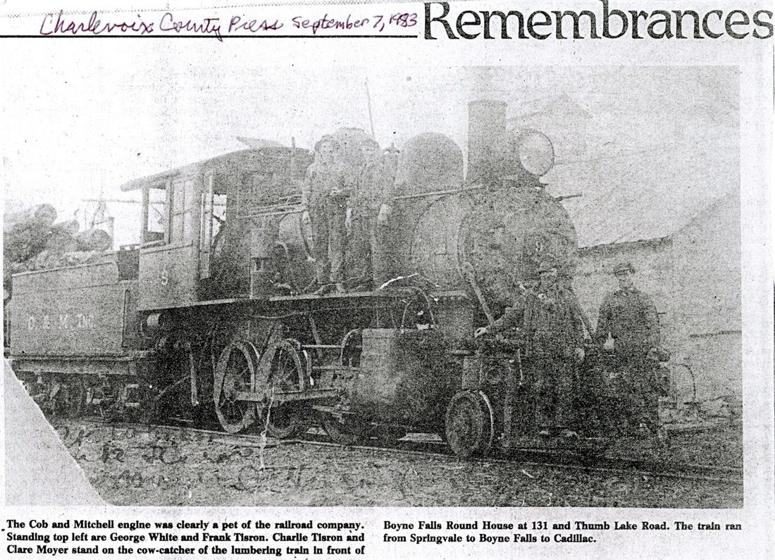
Cobbs & Mitchell Engine # 9 in front of the Boyne Falls Round House ~ Photo/Article submitted by Carl Bajema
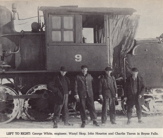
The photo above (submitted by Carl Bajema) from the Charlevoix County Press 7 September 1983 in the "Remembrances" section shows a very similar engine as in the photo directly above it, belonging to James Winslow. This photo identifies the four men as L>R: George White, Frank Tisron, Charlie Tisron, and Clare Moyer. Frank Tisron was listed on the 1930 Chandler Township Charlevoix County census records, so he could have been in Chandler Township as early as in 1920 right after when the previous census had been taken. Frank Tisron was not listed on the 1940 Chandler Township census records. ~ Notice another photo farther up on this page of Engine #9.
Cobbs & Mitchell Engine ~ Photo/Article submitted by Carl Bajema
|
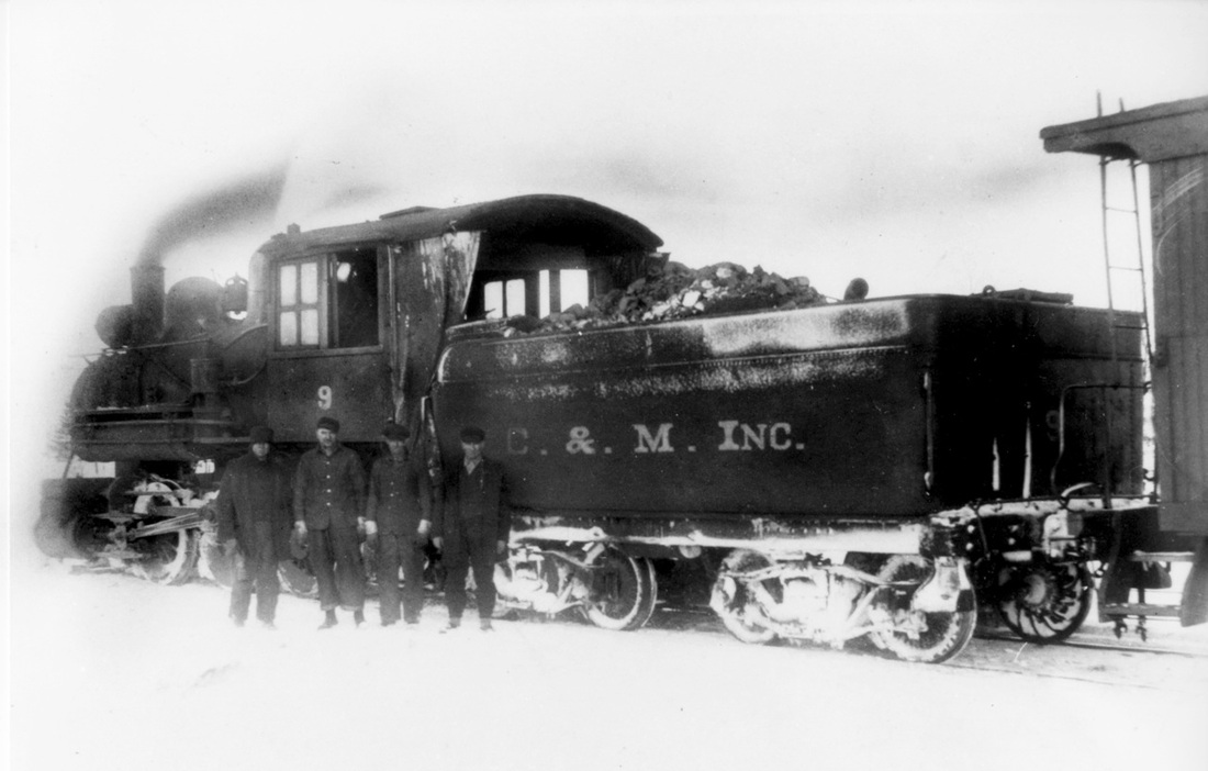
Cobbs & Mitchell Engine #9 ~ Collection of Charlie Conn
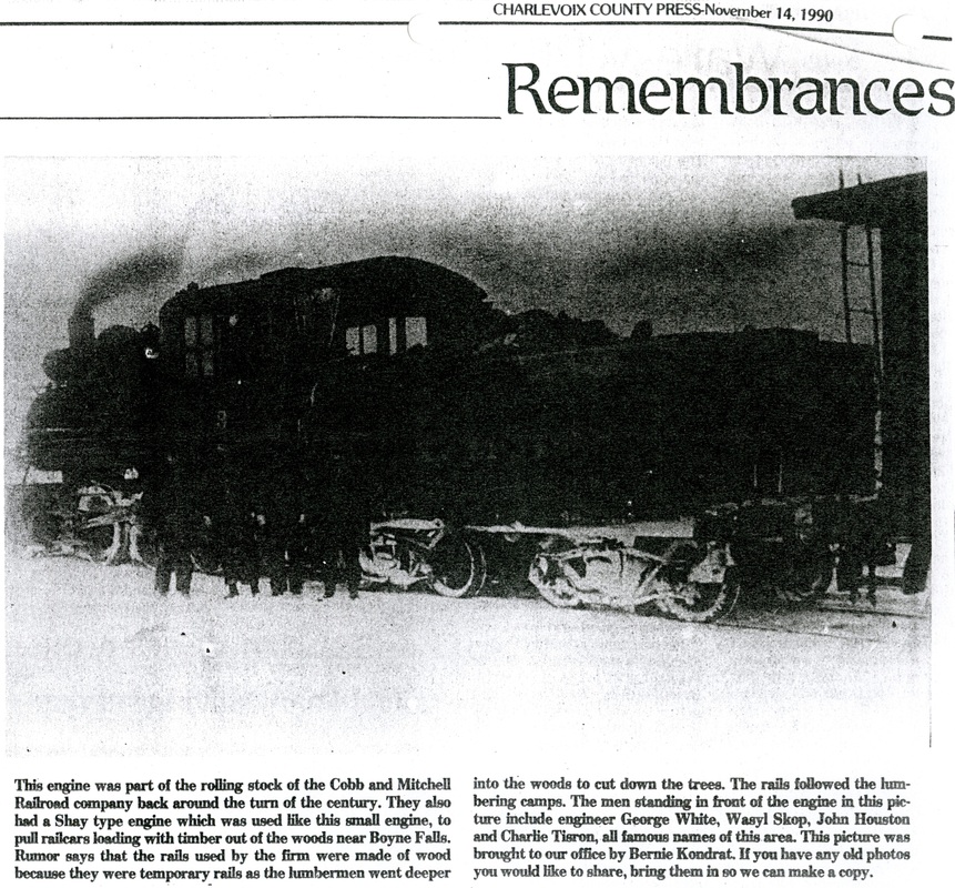
The photo left (submitted by Carl Bajema) from the Charlevoix County Press 14 November 1990 in the "Remembrances" section was almost too dark to view, but the image is still visible, and the text is interesting with the names of the people in the photo. The photo above from the collection of Charlie Conn is the same as the left photo, but much clearer. So the text and the clearer photo complement each other.
|
From "A Pictorial History Of The Boyne Valley Area"
|
From "A Pictorial History Of The Boyne Valley Area"
|
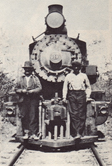
The two above photos are of Cobbs & Mitchell Railroad Engine #9. They were two of the many photos shared in A Pictorial History Of The Boyne Valley Area compiled in 1976 by The Centennial Book Committee. Local area libraries may have copies of this valuable and interesting hard-to-get book, which includes several other logging photos of the area surrounding Boyne Valley Township Charlevoix County MI. The photo above left includes Wasyl Skop, John Houston, and Charlie Tisron. George White and Charlie Tisron, with two other men, were also included in the photo just above this one. The photo on the above right was labeled: "Standing in front of the Engine #9 in BoyneFalls is Charlie Tisron and George White."
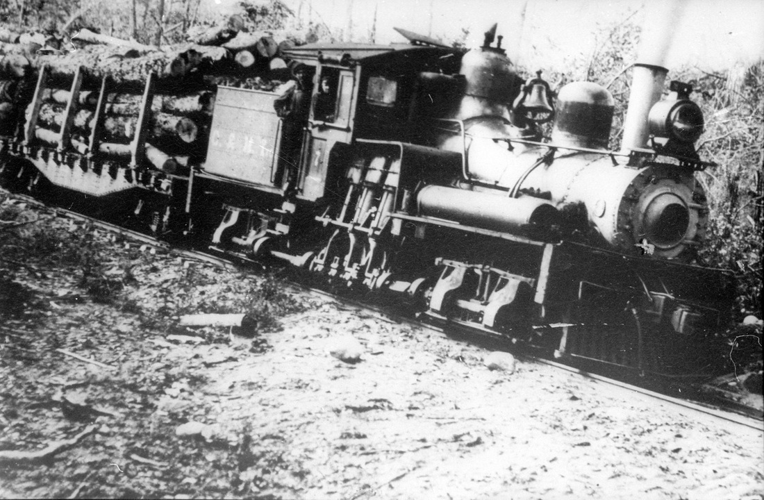
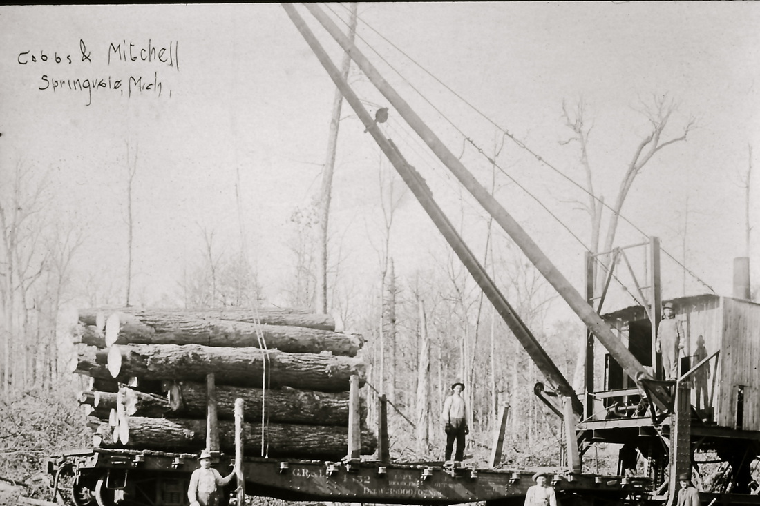
#7 Cobbs & Mitchell loaded with logs ~ Collection of Charlie Conn
|
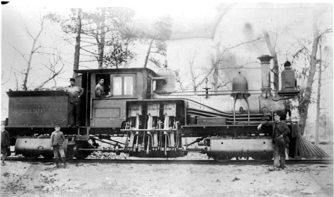
Cobbs & Mitchell Shay Engine ~ Collection of Charlie Conn
|
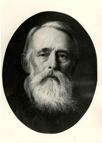
Ephraim Shay ~ Harbor Springs MI
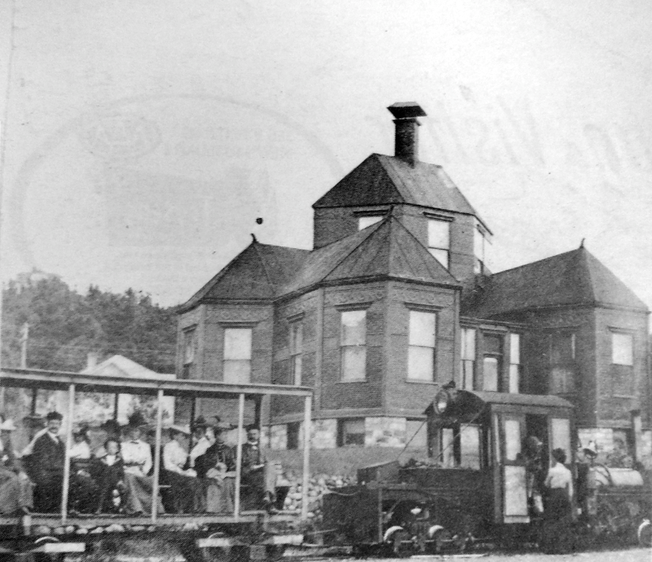
1902 ~ Shay Home in Harbor Springs
|

Business Card For E. Shay & Son of Harbor Springs MI... Creator Of The Shay Engine
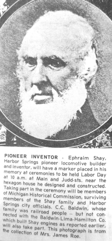
Ephraim Shay ~ Undated Petoskey News Review
|
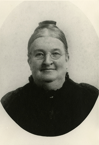
Mrs. Ephraim Shay ~ Harbor Springs MI
Later Years: Shay House designated as a Michigan Historic Site
|
Cobbs & Mitchell RR Springvale MI ~ Collection of Charlie Conn
Cobbs & Mitchell Engine ~ Collection of Charlie Conn
Cobbs & Mitchell Engine House ~ Collection of Charlie Conn
According to his WWII Registration card for June of 1918, Dewey Alex "Dude" Bush, 21 years old, was employed by Cobb and Mitchell Farm in Chandler Township Charlevoix County MI. Rodger Howard thinks he remembers that the farm of Ash and Zella Stewart in later years, had previously been known as the Cobbs and Mitchell Farm. Does anyone else have memories, or records, of this information?
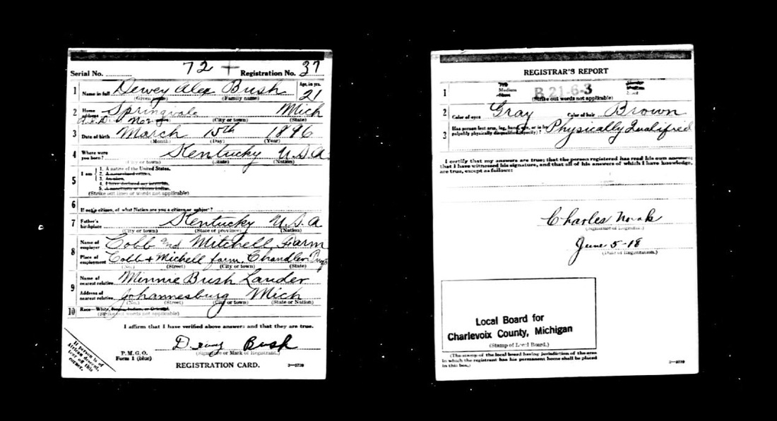
5 June 1918 ~ Cobb and Mitchell Farm
Article Below: Yes, probably just as Rodger Howard remembered above, the Cobb and Mitchell did have a farm.
I am still looking for the memories of this by others???
I am still looking for the memories of this by others???

8 August 1919 ~ Charlevoix County Herald article from the "Farm Bureau Notes"
This court case of action by Nels Boisen against Cobbs & Mitchell Inc. filed with the Supreme Court of Michigan 12 March 1907 is interesting because it gives a sense for the operation of the Cobbs & Mitchell Railroad which was run in the Springvale area. The case stated that Cobbs & Mitchell Inc. was "A company operating a railroad for logging and other private purposes, which did not solicit passenger traffic, had no passenger cars or train schedule, and whose conductors were expressly instructed not to allow passengers to ride elsewhere than in the caboose, owed no duty to provide for the safety of a person riding in disobedience of such instruction, and was not liable for injuries to a person contracting with one of its conductors to be carried in a caboose to his destination, who was subsequently directed by such conductor to finish his journey upon a flat car."


On the following report, it appears that someone possibly in the Geological Survey Division Department of Conservation was interested in reading the atmospheric pressure in various locations visited, on what seems to be for surveying or reading the land on a route covered by mostly railroads. The aneroid barometer can read changes with altitude which could help to give elevations of land.
Upon further research these notes were taken by Frank Leverett who was a noted geologist, very interested in glacial geology, as memorialized in his obituary. His notes that pertain to traveling from Boyne Falls to the Village of Springvale begin on 23 September 1902 at 7 a.m. with "Aneroid reading of 29.200 at Boyne Falls, 711 feet; 29.225 at the roundhouse of railroad, 1/2 mile north… There is a bank east of the roundhouse 20 feet ± high, that may mark the edge of Lake Algonquin. Another drop of 10 feet is made to the swamp just west of the roundhouse. The swamp extends north along the railroad and it seems quite probable that Lake Algonquin surrounded the hills north of Boyne Creek." Of interest to the topic of the Cobbs & Mitchell Railroad and Springvale, is the description of the land and surroundings on Frank Leverett's travels that day in 1902. Frank Leverett proceeded with turning "north at middle of line of Sections 29 and 30, Chandler Township, and soon descent to a swamp. Aneroid 29.200.
Aneroid 28.955 at Cobb and Mitchell's station, south side of Section 2 = 940 feet ± A.T., Springvale Post Office, at 11 a.m.; 28.970 at Springvale at 12:20 p.m. 28.930 on knolls north, near center of Section 2; 28.970 in basin at north side of Section 2, by school house. There are sharp hummocks in Section 2, with cobbles and small boulders on them. Aneroid 28.900 on hill in northeast corner of Section 2 = 1,000 feet.
The southeast corner of Section 36, and parts of adjoining sections, are on a lower plan than that at Springvale. Aneroid 28.910 ±. This valley runs north several miles up the Cobb and Mitchell railroad and is said to rise northward. It is a dry valley, no stream showing where I cross it near the county corners. It is 1/3 of a mile ± in width. I continue east, rising to upland near east end of line of Sections 6 and 31. Aneroid 28.865. I cross a small basin and then rise to a high ridge. Aneroid 28.770 = 1,100 feet ± A.T. It is an elevated upland for 2 miles or more east from here, or about to the Michigan Central railroad.
Aneroid 28.825 at cross roads, corner Sections 5, 6, 31, and 32. I here turn south and swing southeast to corner of Sections 5, 6, 7, and 8 at school house on edge of a valley. Aneroid 28.985; 29.005 at swamp at intersection with east-west road on line of Sections 7 and 8. There is a ridge between this valley and the swampy one in which the railroad runs west of here. Aneroid 28.910 on crest on wagon road in northeast part of Section 7; 29.000 at railroad by a camp in southwest part of Section 6, in the swamp. I go west, rising to a summit at a clearing and house in Section 12. Aneroid 28.810 = 1,070 feet ±. There are hills nearby 30-40 feet higher, or fully 1,100 feet. Aneroid 28.960 at Springvale at 2:15 p.m. = 940 feet ±.
Aneroid 28.910 at south edge of plain south of Springvale 1/2 mile, where morainic hills set in. Is it not likely that this slope was washed to a plain by border drainage that kept working to lower levels as the ice shrunk to the north? The absence of definite terraces may oppose this view. The angle between the Huron and Michigan lobes seems likely to have been at the curving part of this channel in Section 1 Chandler Township.
Near the south line of Section 11, Chandler, I reached the top of a high hill. Aneroid 28.710 = 1,170 ±. Parts east of the road are 20-25 feet higher. Aneroid 28650 = 1,200 feet at a school house in south part of Section 14. This high upland is thickly strewn with boulders, has considerable till at surface, and has slopes gentle enough to be cultivated easily. Aneroid 28.730 = 1,150 feet at east line of Section 14 - 1/4 mile from south end; 18.685 = 1,190 feet at corner Sections 13, 14, 23 and 24. A knoll 30 rods southwest is 40 feet higher, and 80 rods south from it, the altitude is 1,250 feet. Aneroid 28.670 = 1,200 feet at corner Sections 23, 24, 25 and 26; 28.680 = 1,190 feet ± where a descent begins, 80 rods north of the corner of Sections 25,26, 35 and 36. The surface is hummocky in much of Sections 23, 24, 25, 26, 35, and 36, with little knolls of 1-2 acres among larger knolls, and on the slopes of larger knolls boulders are numerous. Aneroid 28.700 at corner Sections 25, 26, 35 and 36. It is 20-25 feet higher 20-30 rods west. Aneroid 28.780 = 1,100 feet at a basin near middle of line of Sections 35 and 36.
Aneroid 28.680 = 1,190 feet on hill north of east end of Thumb Lake at 3:50 p.m.... Aneroid 29.200 on upper bank at cemetery 1/2 mile north of Boyne Falls. This is 15 feet above the railway and Cobb and Mitchell's roundhouse. Aneroid 29.215 at swamp at roundhouse. This 4-5 feet lower than the roundhouse. Aneroid 29.190 at Boyne Falls, 711 feet at 6:00 p.m.
There are no flowing wells here, but in some cases, wells 30 or 40 feet deep have flowed. Charles Crates, in south part of village, has one 27 feet that nearly flows."
6 January 1925
Cadillac Evening News ~ Page 1
MAY FARM PART OF LUMBER FIRM GIFT
STATE LOOKING OVER POSSIBILITIES OF COBBS & MITCHELL CUTOVER LANDS.
Cadillac Evening News ~ Page 1
MAY FARM PART OF LUMBER FIRM GIFT
STATE LOOKING OVER POSSIBILITIES OF COBBS & MITCHELL CUTOVER LANDS.
Lansing, January 6 (United Press)---Arrangements for farming cleared land of the Cobbs & Mitchell Co., a 38,000 acre gift to the state, will be investigated by the administrative board, it was announced today.
The land in Charlevoix, Emmet and Cheboygan counties was donated to the state on condition that all 1924 taxes be assumed. Payment of the taxes, estimated at $38,000, was authorized by the administrative board today.
Renting or selling the farming land is designed to help communities which would lose by having this land taken off the tax rolls.
~~~~~~~~~~~~~~~~~~~~~~~~~~~~~~~~~~~~~~~~~
The above Cadillac Evening News article announced that Cobbs & Mitchell donated 38,000 acres to the State of Michigan to avoid paying taxes. Logging was done in Chandler Township, so Springvale no longer had the lumbering industry for economy. This time frame of 1925 also explains the difference in the listing on the 1901 Chandler Township plat book of so much Cobbs & Mitchell owned land, and then on the 1930 plat book for Chandler Township most of the same lands were listed as State Land, with no Chandler Township land owned by Cobbs & Mitchell. This historical article thus explains how/why this change of ownership from Cobbs & Mitchell land to State Land came to be. In 2013, The State of Michigan still possesses 75% to 80% of Chandler Township.
In comparing the two maps; 1901 to 1930, some of the changes in the particular sections are as follows:
Cobbs & Mitchell Land changed from 1901 to State Land in 1930:
Section 01: C&M 644.10 acres > State 644.10 acres
Section 02 C&M 160 acres > State 160 acres
Section 03: C&M 640 acres > State 483.60 acres & E. Kennedy owned 163.44 acres
Section 04: C&M 280 acres > State 606.28 acres
Section 05: C&M 597.73 acres > State 557.73 acres
Section 06: ALL privately owned both 1901 & 1930
Section 07: C&M 640 acres > State 623.20 [Mrs. Frank Stewart owned other acres]
Section 08: C&M 560 acres > State owned half ~ 320 acres [Mrs. Frank Stewart owned half the section ~ 320 acres]
Section 09: C&M 640 acres > State 560 acres [Benjamin owned 80 acres]
Section 10: ALL privately owned both 1901 & 1930
Section 11: C&M 500 acres > State 560 acres
Section 12: C&M 488 acres > State 560 acres
Section 13: C&M 640 acres > State 640 acres
Section 14: Privately owned > State owned 80 acres
Section 15: C&M 640 acres > State 640 acres
Section 16: C&M 640 acres > State 400 acres
Section 17: C&M 640 acres > State 280 acres
Section 18: C&M 75.85 acres > State 160 acres
Section 19: C&M 400 acres > State 120 acres
Section 20: C&M 360 acres > State 60 acres
Section 21: C&M 640 acres > State 640 acres
Section 22: C&M 160 acres > State 320 acres
Section 23: C&M 480 acres > State 480 acres
Section 24: C&M 120 acres > State 120 acres
Section 25: C&M 600 acres > State 600 acres
Section 26: ALL privately owned both 1901 & 1930
Section 27: C&M 560 acres > State 480 acres
Section 28: C&M 400 acres > State 400 acres
Section 29: C&M 560 acres & 80 acres owned by Wayne County Savings Bank > State 80 acres [Boyne City Bank owned 120 acres]
Section 30: C&M 72.8 acres > State 72.8 acres
Section 31: C&M 640 acres > State 560 acres
Section 32: C&M 560 acres > State owned 640 acres
Section 33: C&M 640 acres > State 640 acres
Section 34: C&M 160 acres > State 160 acres
Section 35: C&M 480 acres > All privately owned with E.L. Stafford 480 acres
Section 36: ALL privately owned both 1901 & 1930

30 January 1925 ~ Petoskey Evening News
1925
Springvale was a company town–
when Cobbs & Mitchell's lumbering operation railroad was torn up,
the town was done.
Springvale was a company town–
when Cobbs & Mitchell's lumbering operation railroad was torn up,
the town was done.

27 May 1925 ~ Petoskey Evening News
~~~~~~~~~~~~~~~~~~~~~~~~~~~~~~~~~~~~~~~~~
One of the houses within the Village of Springvale in about 1925/26 was sold to Orla A. (30 May 1890 ~ 21 February 1959) and Rosamond Totten. The Tottens then moved the house to Wilmot Township Cheboygan County Wolverine MI where it is still standing in 2013 (according to William Yingling). Although Wilmot Township is in Cheboygan County, rather than in Charlevoix County, Wilmot Township is located adjacent to Chandler Township, so Wilmont Township is not any great distance. Cobbs & Mitchell owned a great deal of land in Wilmont Township as well.
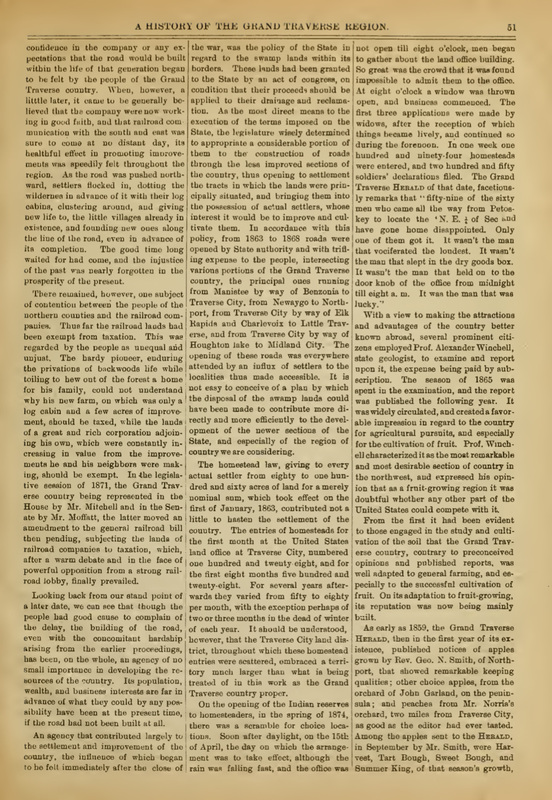
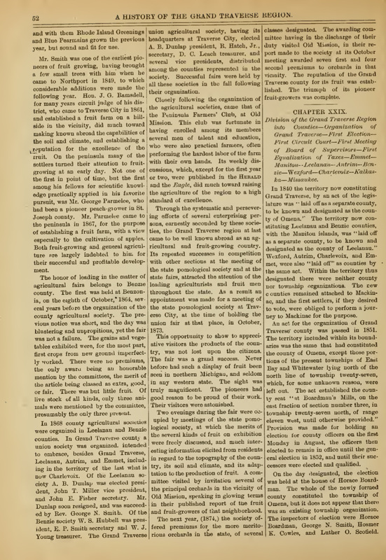
A History of the Grand Traverse Region published in 1884 reveals on pages 50, 51, and 52 as shown below why Chandler Township presently has so much state land, later on, and even into 2014. When the book was published in 1884, Grand Traverse Region included land farther north than just the Grand Traverse County known in 2014. The area was settled sooner for several reasons... "Accordance with treaty stipulations, several townships of choice land were withheld from market for Indian reservations." Another reason was "the granting of every alternate section of extensive tracts of land as subsidies to certain railroad companies, for the building of railroads into the country from the south. The original intention of the general and state governments, no doubt, was to speedily open the northern wilderness to practical settlement and improvement. Such would have been the result, had the companies been held to strict compliance with the terms of the grant. But they were allowed to hold the lands, or more strictly speaking, the lands were held for them by the state, being kept out of the market, for a long term of years after the expiration of the time in which the roads were to have reached the heart of the northern wilderness, while in roadmaking practically nothing was done. The citizens of the northern counties regarded the course of the national and State governments as unjust and oppressive to their section of the state. There were some exciting contests in the State legislature, in which their representatives vainly strove, against overwhelming odds, to induce that body to compel the fulfillment of the terms of the grant or cause the lands to be restored to market. Among the earnest advocates in that body of the interests of the northern counties, was Mr. Dixon, of Charlevoix"... Later, "as the road was pushed northward, settlers flocked in, dotting the wilderness in advance of it with their log cabins, clustering around, and giving new life to, the little villages already in existence, and founding new ones along the line of the road, even in advance of its completion. The good time long waited for had come, and the injustice of the past was nearly forgotten in the prosperity of the present. There remained, however, one subject of contention between the people of the norther counties and the railroad companies. Thus far the railroad lands had been exempt from taxation. This was regarded by the people as unequal and unjust. The hardy pioneer, enduring the privations of the backwoods life while toiling to hew out of the forest a home for his family, could not understand why his new farm, on which was only a log cabin and a few acres of improvement, should be taxed, while the lands of a great and rich corporation adjoining his own, which were constantly increasing in value from the improvements he and his neighbors were making, should be exempt. In the legislative session of 1871, the Grand Traverse country being represented in the House by Mr. Mitchell and in the Senate by Mr. Moffatt, the latter moved an amendment to the general railroad bill then pending, subjecting the lands of railroad companies to taxation, which, after a warm debate and in the face of powerful opposition from a strong railroad lobby, finally prevailed. Looking back from our stand point of a later date, we can see that though the people had good cause to complain of the delay, the building of the road, even with the concomitant hardship arising from the earlier proceedings, has been on the whole, an agency of no small importance in developing the resources of the country. Its population, wealth, and business interest are far in advance of what they could by any possibility have been at the present time, if the road had not been built at all.
Because the railroad company properties in Chandler Township Charlevoix County began to be taxed, when the railroad company no longer had need of the once timbered land, and was ready to pull out of Springvale and all of Chandler Township, the acres and acres of railroad land went back to the state just as was reported in a couple of articles higher on this webpage:
"The land in Charlevoix, Emmet and Cheboygan counties was donated to the state on condition that all 1924 taxes be assumed."
Thus, Chandler Township has remained 75% to 80% state owned land to this day in 2014.
A History of the Grand Traverse Region ~ 1884 Page 50
|
A History of the Grand Traverse Region ~ 1884 Page 51
|
A History of the Grand Traverse Region ~ 1884 Page 52
|
~ Cobbs & Mitchell Inc. Camps Near Springvale ~
It is thought that all of...
The following Cobbs & Mitchell Camps were
in the Chandler Township Area:
23, 32, 38, 41, 42, 48, and 50.
The following Cobbs & Mitchell Camps were
in the Chandler Township Area:
23, 32, 38, 41, 42, 48, and 50.
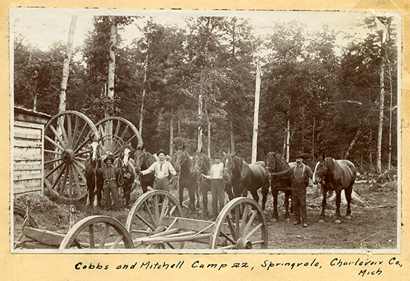
Has anyone heard of a Camp 22 or a 31 in Chandler Township?
See the photo of Cobbs & Mitchell train #7 labeled on the postcard, and also labeled Camp 31 farther up on this same webpage. Contact Karla Howard Buckmaster with any information.
In an undated Petoskey News Review article written by John Kilborn which I recently came across,
he mentioned the Camp 22, and the Camp 50 which I previously had not known.
See article posted below the photo of Camp 22 below...
Please contact the webmaster if any additional information about this photo is known.
Little Traverse Historical Society Photo Collection (Undated)
John Kilborn Tells of His Early Early Days in Lumberjack Camps...
PHS Football Stadium, Site of Logging Camp
By John Kilborn
(Undated Petoskey News Review Article)
These facts will give you an idea of what logging and the logging industry were like in the era around the turn of the century 65 years ago.
In those days, power saws, caterpillar tractors, trucks and such power equipment were not heard of, presenting a real task for lumbermen to bring their logs to the ready market.
The cutting of the timber was done by two men with a cross-cut saw and each man had an axe. The skidding was done with horses, the decking and loading on sleighs was done by a crew of three men, a team and a single chain.
For loading in the sleigh, two skids were placed against the main logs that were already on the sleigh. The decking chain is passed around the log that is to be loaded and fastened to a log on the sleigh by a hook called a swamp hook, The team, being on the opposite side, are hitched to the other end of the chain and they pulled the log up the skids to the top of the load. A man with a cant hook worked on each end of the log to keep it balanced in the chain as it went up the skids. These men were known as ground men. A third man with a cant hook worked on top to place the log on the load and he was called a top loader.
DANGEROUS
The cutting and handling of logs was a dangerous operation for a man with no experience, one that didn't know or realize where the danger was, and many men lost their lives and had legs broken but, for a regular lumberjack that knew his job, I don't think any more men were hurt than at lots of other work where there was any danger encountered.
The first large scale logging operation I can remember was in 1898. A camp was just a short distance from our school and they took the timber off of a a large tract of land that adjoined our farm. This crew, consisted of about 30 men and eight teams of large horses. The timber was cut and skidded in the fall and hauled by teams and sleighs when the winter came, taking the timber to the Thomas Foreman and Company mill at Petoskey. The mill was where the present Petoskey High School football stadium is located today.
CRUSHED BY A LOG
Being interested in what was going on and to watch the mill operations I used to go out to the woods when I could on Saturdays. One Saturday after the snow came and they were hauling I was out in the woods watching them load. One high skid way broke down and one of the men that was loading (groundsmen) was crushed and killed instantly by a falling log. There were several men and teams waiting to be loaded. The men took some horse blankets and wrapped the body and brought it to Petoskey on an empty sleigh. They made me realize the power and danger of logging. In 1900 there was a vast amount of virgin hardwood timber within a radius of 20 miles of Petoskey to the north, south or east. This was being bought up by large logging concerns. As a result, there was a lot of logs hauled into Petoskey by teams and a lot shipped on cars. Petoskey wasn't known as a sawmill town or a hangout for lumberjacks as much as some of the towns near here such as Boyne City. White Company, located there, had several large saw mills and a flooring factory, Von Platten Company; a large saw mills, the Boyne City Lumber Company; the chemical plant and a blast furnace.
PETOSKEY MILLS
In Petoskey there was the Thomas Foreman saw mill and flooring factory that burned to the ground in 1901; The W.L. McManus Lumber Company that operated here as long as the timber lasted; the Michigan Maple Block Company that used to operate a saw mill; the combined shingle and saw mill operated by L.G. Grimes and the Baurlee Brothers saw mill and broom handle factory along with the few other small operations.
The largest timber holdings and logging operation nearest to Petoskey were the Cobb and Mitchell Company's spreads. Their saw mills were located at Cadillac. They had large timber holdings in the southeast part of Bear Creek township, Springvale township, parts of several townships in Charlevoix county and some in Cheboygan county.
Their railroad branched off the Grand Rapids and Indiana Railroad, now known as the Pennsylvania Railroad, at Boyne Falls, going north and east through the timber at a distance approximately 15 miles to Section 11, Chandler township, Charlevoix county where a headquarters was established for their operations. This was named Springvale.
SPRINGVALE BOOMED
At this location there was built a town hall, a dance hall, a hotel and a large store that was in operation for 22 or 24 years. They handled everything that was in use at that period from a spool of thread, groceries of any amount or kind and a good supply of horse shoes and harnesses.
Later, several small homes were built in the near vicinity.
This railroad out of Boyne Falls was built around 1898 as near as I can remember. As time went on and as timber was cut off along the railroad, the company built branch lines in other sections of timber to be logged off, then pulled up the steel rails and moved to other timber sections.
A number of different camps had to be built to house the horses and lumberjacks to log off this vast amount of growth. The first camp I knew was Camp 22 about four miles north-east of Boyne Falls. The last camp the company built was Camp 50 in 1922, making a total of 28 camps that I can remember that were built and torn down.
They operated three camps at a time and they would often have independent contractors, known as 'jobbers.' They would take a contract to cut, skid, haul to the railroad and load on cars a certain section of timber for certain price per thousand feet.
THE 'WALKING BOSS'
For such an operation as this size, the company had a woods superintendent, known as a 'walking boss.' He had charge of the entire operation and he in turn had a foreman for each camp and a manager for each store. It was up to him to decide where the branch railroads were to be built in the timber and after the railroad was in the location, he would build the camp where it would be most convenient to the timber. When locating a camp, a good supply of water was necessary and this was also taken into consideration, even before running the lines in.
A camp of that period had about 60 to 80 men and 10 to 14 pairs of horses in each camp. The buildings of the camp consisted of: No. 1, the 'cookcamp,' a large building approximately 24 feet wide by 60 feet long; No. 2, barn for 12 pair of horses, 30 feet wide and 60 feet long; No. 3, bunk houses for the men. (Some camps housed the men in one building but most camp foremen would rather have two bunk houses.) For a larger crew of about 35 or 40 men, one bunk house worked out best; No. 4, the blacksmith shop where all repairs were made in equipment, horses shod, sleighs and big wheels were built and the whiffle trees and neck yokes were made by hand; No. 5, camp office, where the foremen, scaler and time keeper slept. In addition there was the camp store of 'van' which was attached.
In the van was most of anything that a lumberjack would need such as plenty of Peerless or Giant tobacco, socks, shirts, rubbers, underwear, wool pants, caps and mitts.
No. 6 was the filer's shack where one man did all the filing for all the saws and each gang of sawyers would bring their saw in to camp at night or when it needed to be sharpened and took out a sharp one. The filer always had a good supply of saws to hand out and would have a sharp one in stock at all times.
WORKED LONG HOURS
In the period before World War I, the scale of wages didn't vary much from one year to the next. The camps paid by the month, a certain amount plus board and there was no hourly pay in those days. The workday started shortly before daybreak and you worked until it was too dark to see, often 10 or 12 hours a day, six days a week.
Following is a table of the average wages paid to lumberjacks, based on so much a month and board:
Swampers, $26; loaders, $28 to $32; top loaders, $32 to $35; teamsters, $30 to $35; blacksmith, $35 to $40; camp cook, $40 to $50; camp cookee (helper) $20 to $26.
In the early days 50 or 60 years ago, woods work was about the only kind of work where a young man could get a job at any time to earn some extra money.
I have worked in the camps as a lumberjack, as a swamper, teamster and loader in my younger years and later as a contractor or 'jobber' for the W.L. McManus cCompany, the Michigan Maple Block Company of Petoskey, the Jackson and Tindle Company of Pellston and the VanAvery Brothers of Van. In 1922 to 1931 I was in the Upper Peninsula where I contracted for the Sawyer, Goodman Company on quite an extensive operation at that time. One season we had an average of 100 men and 20 pairs of horses working at one time.
Later, after retiring from the lumber business I was the sheriff of Emmet County and then state representative of Lansing and I could tell many more experiences from either of the positions.
Although the camps were no longer running in 1938,
the turn-of-the-century logging camps marked on the 1938 map below were labeled as located in:
Section 1 ~ C&M Camp #48
Section 14 ~ Camp No. 50
Section 17 ~ Camp No. 23
Sections 24 & 25 ~ Camp "49"
the turn-of-the-century logging camps marked on the 1938 map below were labeled as located in:
Section 1 ~ C&M Camp #48
Section 14 ~ Camp No. 50
Section 17 ~ Camp No. 23
Sections 24 & 25 ~ Camp "49"
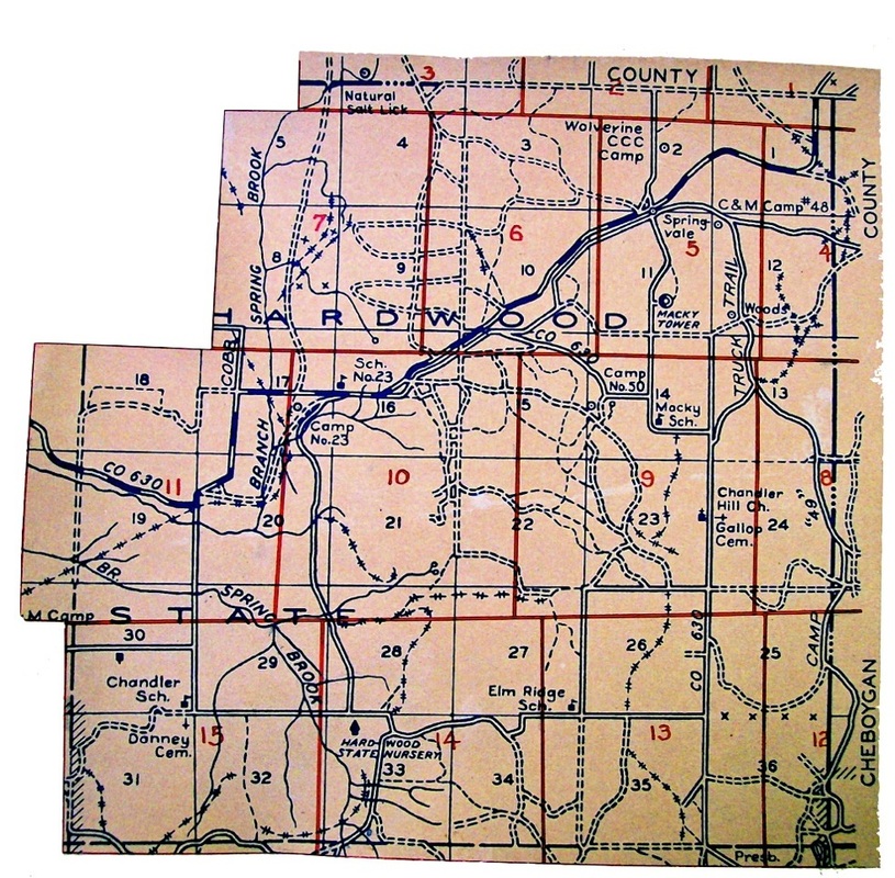
1938 Michigan Department of Conservation Field Administration Division map
Logging could be a dangerous occupation.
2 December 1916 ~ Petoskey Evening News
~ The Boyne City and Southeastern Locomotive Beside Lake Louise ~
(Beside Lake Louise)
(Beside Lake Louise)

Photo submitted by Bill and Angela Kuhn with permission to be viewed only on this Northern Mich~Mash Preserve web site…
Nelson Strong, Chandler Township resident, said that today, people often think that the loggers came into an area and just started cutting everything down, but Nelson said the loggers only cut the species that was in demand. When everybody wanted maple they cut the maple out of the woods... much of the maple from Chandler Township was shipped to the Cadillac Flooring Company. When the maple ran out, and the demand was for a different species, then that species was cut. Eventually, what was left was elm as that was not in large demand by companies for their wood products. Then, the tanneries in the area wanted the elm to use the bark for the tanning process. After the loggers moved on, a group went through and took out the "bungwood" (leftovers), which was shipped to places like the Boyne City Chemical Company. Collecting bungwood was the work of many of the Chandler Hill Howard Brothers, especially when they lived at the Howard Camp in nearby Hudson Township where railroad spurs from the Boyne City and Southeastern Railroad (Later the Boyne City, Gaylord, and Alpena Railroad) which ran the bungwood directly to Boyne City [Photo Above]. The chemical plant made coke for the pig iron plant with a byproduct of crude alcohol which proved even more valuable than the original big timber logs had been.
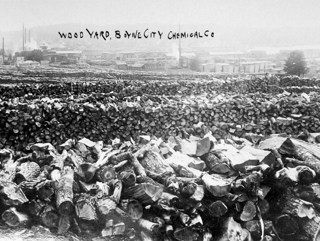
Wood Yard full of "Bungwood" for Boyne City Chemical Company
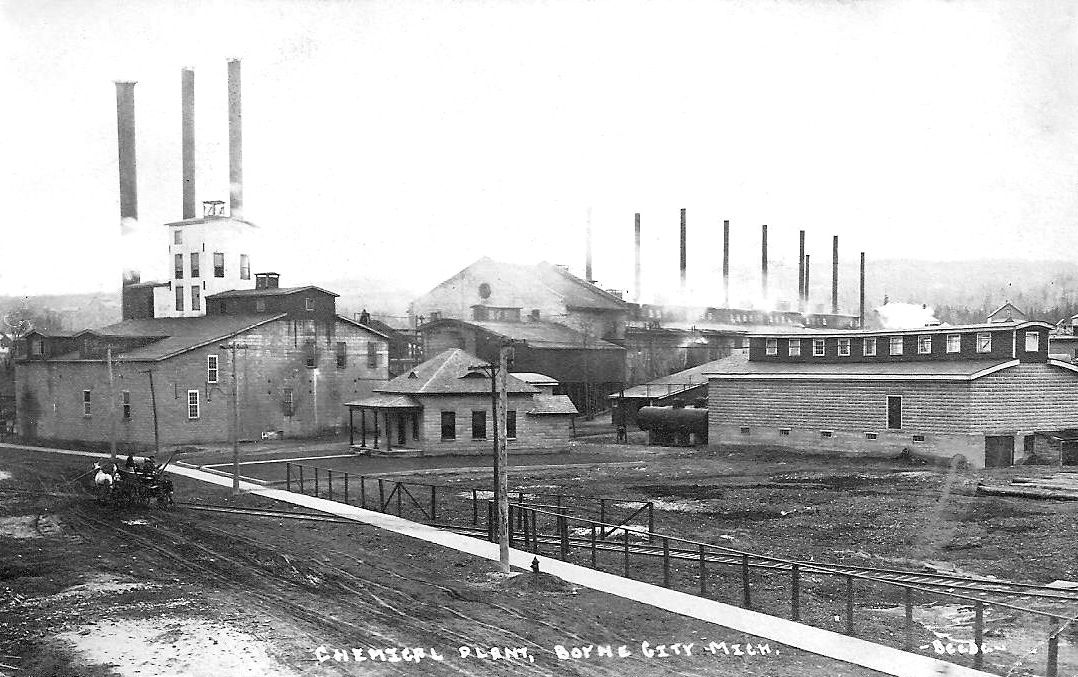
Submitted by Wendy Butka from the Collection of Lila Magee
|

Submitted by Wendy Butka from the Collection of Lila Magee
|
~ Camp 23 ~
of the Cobbs & Mitchell Inc. railroad
of the Cobbs & Mitchell Inc. railroad
Camp 23 was located in Section 17 of Chandler Township... on the Cobbs & Mitchell railroad track before reaching Springvale. The Michigan Department of Conservation Field Administration Division map shows Camp 23 near Cobb Road with a Sch. No. 23 appearing in this map as being located in Section 16, rather than in Section 18 as another map shows for SD No. 4. The photo below shows railroad workers with the Camp 23 water tower behind them; L>R: Roy Waldorf, W. "Tip" Jacobs, Delbert Townsend, Frank Geared.
Cobbs & Mitchell Inc. train... Camp 23
|

Water tower at Camp 23
|
1976
The photos above and directly below show one of
Wiley Latshaw's many buildings on his property that had been home to Camp 23 of the Cobbs & Mitchell Inc. railroad. This building, located on Howard Road, of Wiley's had housed the secondary lumber industry of making butter bowls. |

1976 ~ Old railroad grade off Howard Road near Camp 23/Latshaw Property
The photo below shows the root cellar used for Camp 23. Where was this located exactly?
|
Submitted by Nelson Strong
|
Submitted by Nelson Strong
|

10 July 1907 ~ The Petoskey Record
|

11 July 1907 ~ The Pellston Journal
|
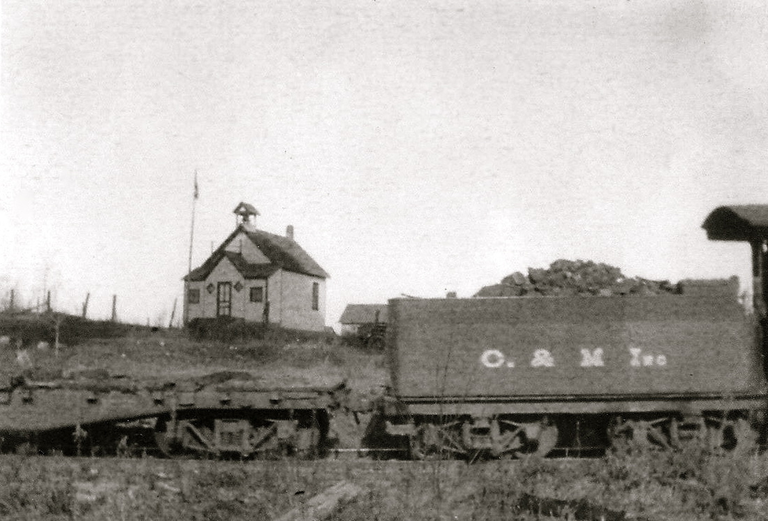
Photo Below: The Blaney School, Chandler Township School (SD No. 6), was in the background, located behind
the railroad tracks with a Cobbs & Mitchell Inc. train used to service the various lumber camps,
and the Village of Springvale farther along on the railroad line.
Wiley Latshaw lived in that Springvale Road school house in later years, and even processed his honey there,
in preparation to ship the honey to Europe.
Submitted by Nelson Strong
20 June 2014 ~ Remnants of an old shed which stood near the school at Camp 23
Photo Below: This was the main office of Cobbs & Mitchell Inc. railroad for Camp 23.
In later years after Wiley Latshaw purchased the Camp 23 property, he lived in that house...
and, in its end years, it finally just fell down.
In later years after Wiley Latshaw purchased the Camp 23 property, he lived in that house...
and, in its end years, it finally just fell down.
Submitted by Nelson Strong
Photo Below: Wiley Latshaw stood with his motorcycle in front of his many buildings he owned,
which had been buildings from Camp 23.
which had been buildings from Camp 23.
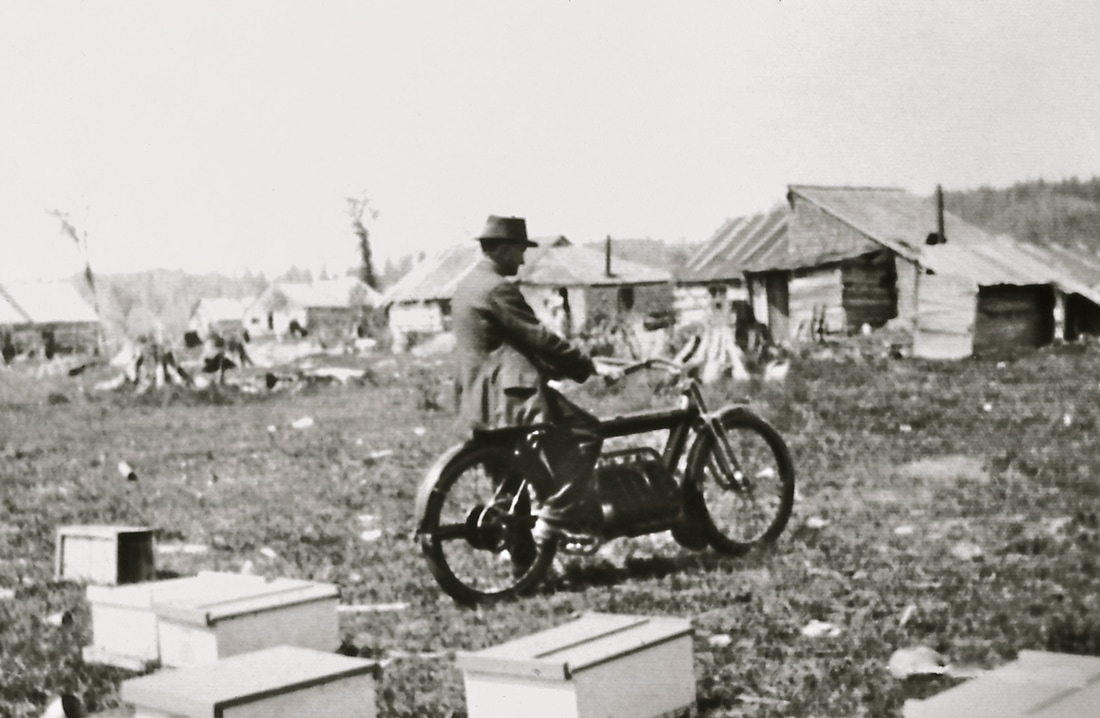
Wiley Latshaw with his motorcycle in front of his many buildings which had been buildings from Camp 23
The Clarion news below included: "The smallpox quarantine over at Camp N.23 has been raised."

22 March 1910 ~ The Independent Democrat
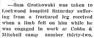
~ Camp 32 ~
of the Cobbs & Mitchell Inc. railroad
of the Cobbs & Mitchell Inc. railroad
Submitted by Wendy Butka ~ Assumed to be Camp 32 Headquarter Camp as located with photo below.
Submitted by Wendy Butka from the Collection of Lila Magee
The photo above was not labeled, but it must be Camp 32 because the photo below was labeled as Camp 32,
and in the photo above, the first two men on the right are both standing on the right side of the photo below.
and in the photo above, the first two men on the right are both standing on the right side of the photo below.
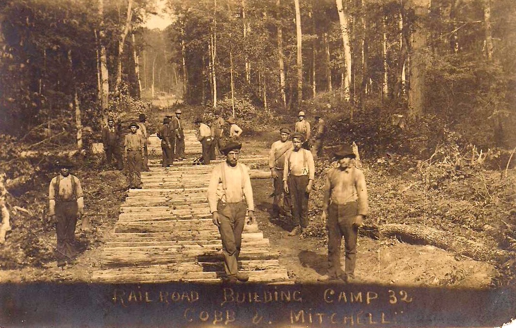
Railroad Building Process Camp 32 ~ Submitted by Wendy Butka
The photo below has the same man... 4 in from the left with the dark open shirt,
as the man in the top photo of Camp 32... standing 6 in from the right in the same dark open shirt.
The man, two in from the left, in the photo below appears to be
the same man labeled as "Bun" (possibly "Burr"?) working the big wheel on the lumbering webpage on this website.
as the man in the top photo of Camp 32... standing 6 in from the right in the same dark open shirt.
The man, two in from the left, in the photo below appears to be
the same man labeled as "Bun" (possibly "Burr"?) working the big wheel on the lumbering webpage on this website.
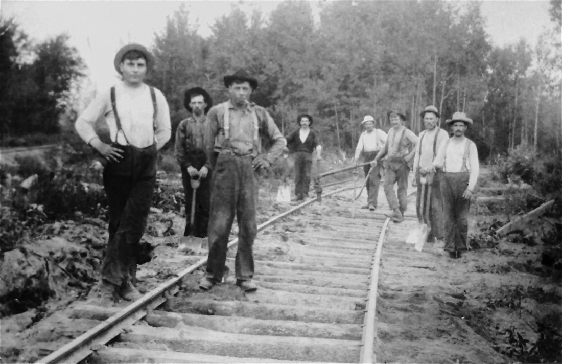
The tool was used to measure the width of the tracks.
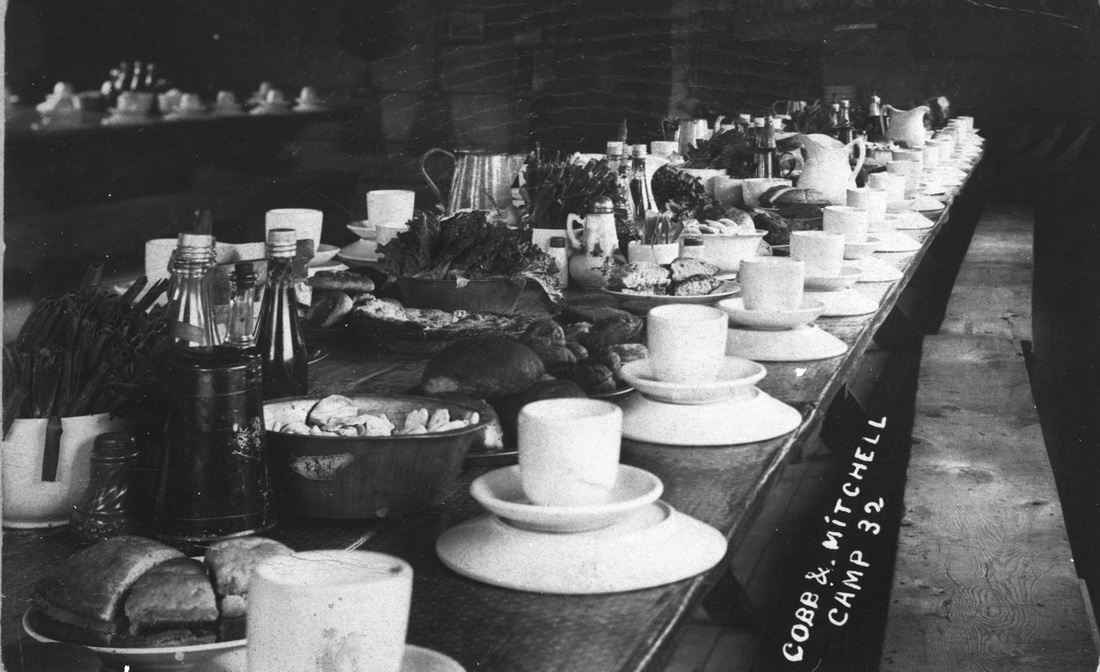
Cobbs & Mitchell Camp 32 dining hall table ~ Collection of Charlie Conn
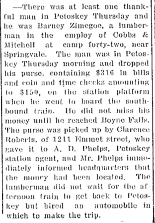
31 October 1910 ~ Petoskey Evening News
~ Camp 41 ~
of the Cobbs & Mitchell Inc. railroad
of the Cobbs & Mitchell Inc. railroad
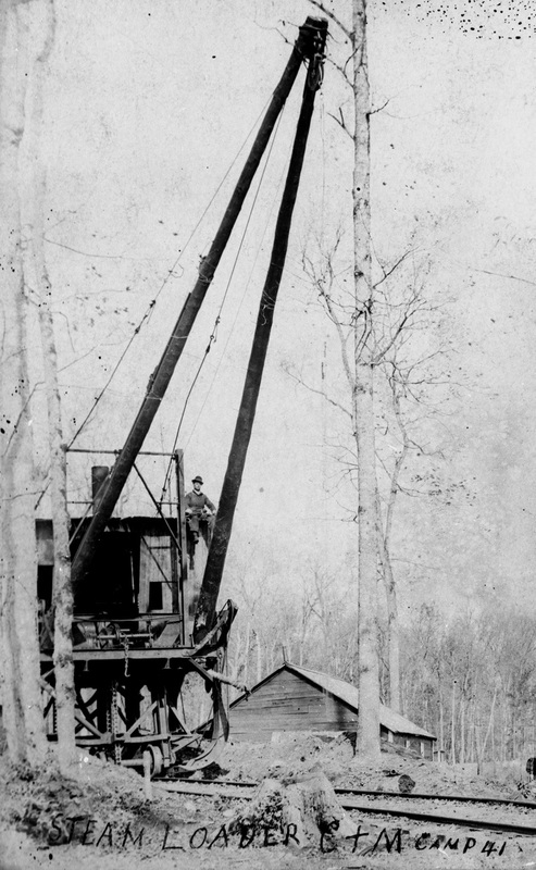
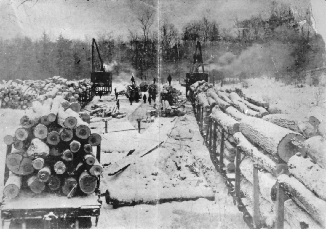
Cobbs & Mitchell Camp 41 Steam Loader ~ Collection of Charlie Conn
|
Cobbs & Mitchell Camp 41 Steam Loader
|
Camp 41 Cobbs & Mitchell Springvale Mich
~ Camp 42 ~
of the Cobbs & Mitchell Inc. railroad
of the Cobbs & Mitchell Inc. railroad
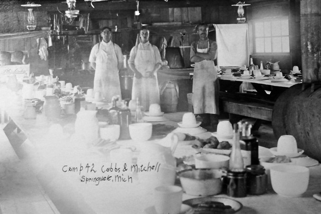
Camp 42 Cobbs & Mitchell Springvale, Mich
Obituary Below: James Talbot's obituary did not state which number camp he was the cook, but it did state that "He was a cook for Cobb's & Mitchell lumber camp in Springvale..." So, he was very likely in a cooking setting such as in Camp 42 in the above photo.
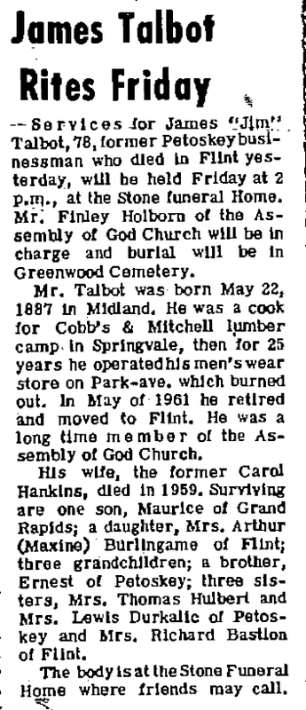
1 December 1965 ~ Petoskey News Review
27 November 1914 ~ Petoskey Evening News

Track trestle Cobbs & Mitchell Camp 42
|
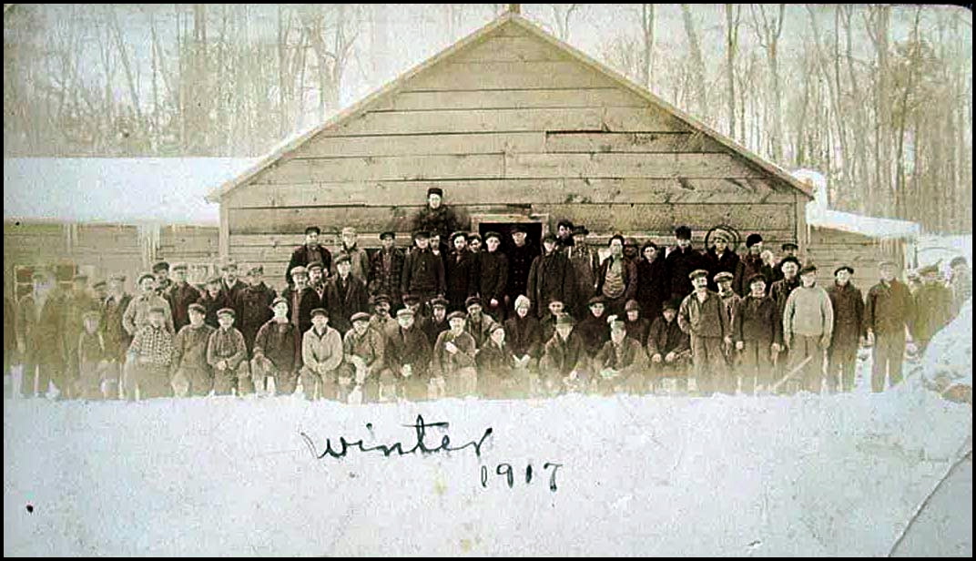
Camp 42 Cobbs & Mitchell ~ Winter of 1917
|

Cobb & Mitchell Camp 42 Springvale Michigan
~ Camp 44~
of the Cobbs & Mitchell Inc. railroad
of the Cobbs & Mitchell Inc. railroad
Camp 44 was the last of the Springvale Lumber Camps to log... and that ended in 1925.
1917 US Registration Card below shows that
John Martin Bush had been employed by Cobb & Mitchell Camp #44.
John Martin Bush had been employed by Cobb & Mitchell Camp #44.

1917 US Registration Card
Article Below: Does anyone know where C&M Camps 31 and 33 were located?

13 April 2010 ~ The Petoskey Record
~ Camp 46~
In 2016, when I came across this news article, it was the first that I had ever read, or heard, of anything about a Camp 46 in Springvale. Can anyone else add to this information for a Camp 46? Thora Wilber Conners, who wrote the wonderful description below of lumbercamp life to Mrs. Sumerix, was found with her immediate family on the 1920 Chandler Township census:
Wilber
Thad C Wilber abt 1876 Ohio Head [Scaler Lumber]
Dorothy Wilber abt 1886 Michigan Wife
Thora Wilber abt 1903 Michigan Daughter
Louise Wilber abt 1913 Michigan Daughter
Marie Wilber abt 1920 Michigan Daughter
I believe that the Melford family that Thora wrote about was actually the Jim and Helen Milford Family. The Goff family Thora mentioned was also listed on the 1920 census for Chandler Township.

17 March 1977 ~ Straitsland Resorter

Close-up of same photo from the article above...
|

Close-up of same photo from the article above...
|

9 June 1920 ~ Petoskey Evening News
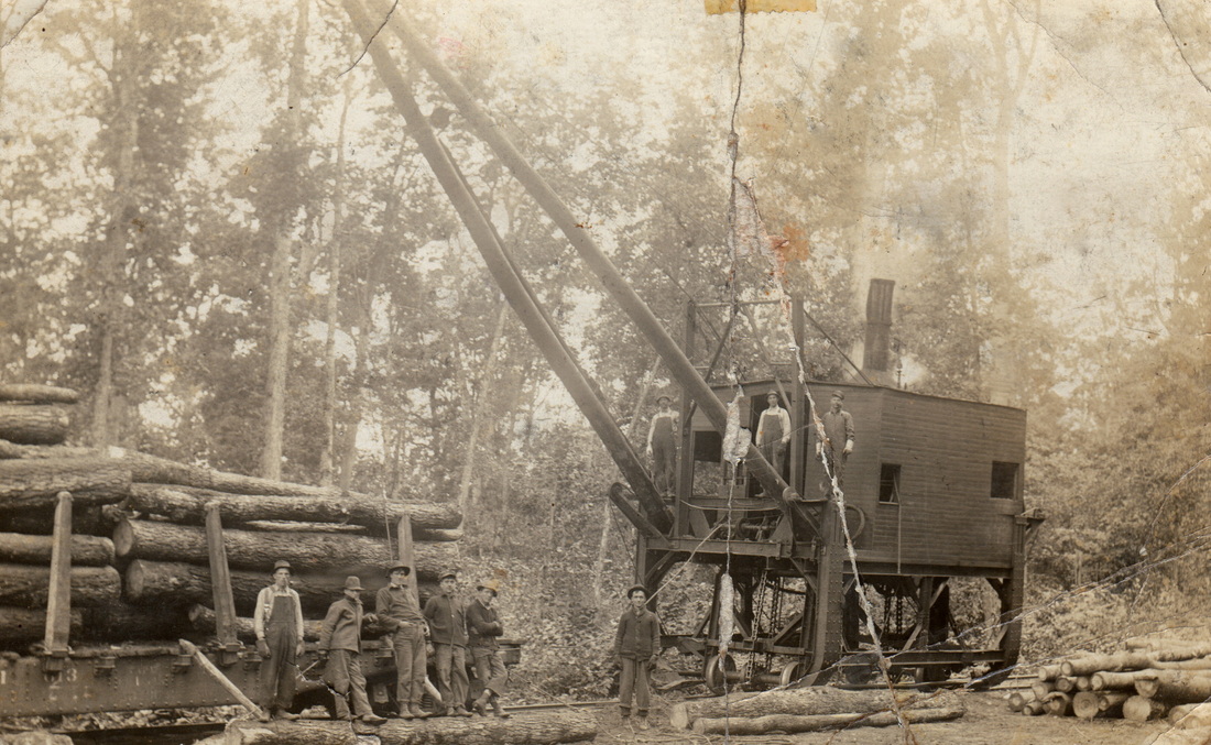
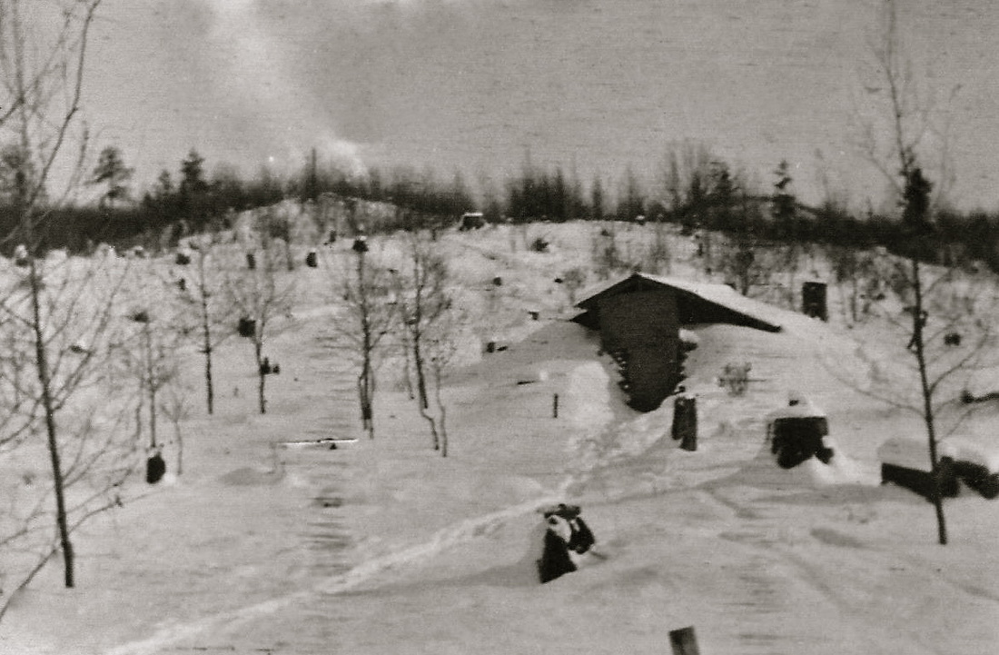
~ Cobbs & Mitchell Railroad Operation Near Springvale ~
Taken about 1923 near Springvale of one of the lumber camps (unlabeled) of the Cobbs & Mitchell Railroad

7 DEcember 1950 ~ Northern Michigan Review
~ Camp 47~
of the Cobbs & Mitchell Inc. railroad
of the Cobbs & Mitchell Inc. railroad
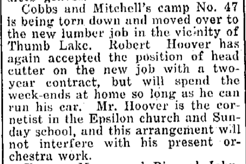
1 June 1922 ~ Petoskey Evening News
~ Camp 50~
of the Cobbs & Mitchell Inc. railroad
of the Cobbs & Mitchell Inc. railroad
Nelson Strong who has lived in Chandler Township his entire life, remembers that Camp 50 was down in the gully between Tracy Penfold's and Calvin Penfold's property, within about a mile. That meant it was across the road from where the Tousley's lived, and behind where George Fetterly and George Gallop lived. Nelson said Camp 50 could be reached by walking into the woods from where the Mackie School was located. Nelson visited the Camp 50 site one time, and he found an old horse trough, and what appeared to have been where a cook house had been, because a bunch of old tin cans were in that area.

10 April 1924 ~ Petoskey Evening News

23 January 1925 ~ Petoskey Evening News

27 May 1925 ~ Petoskey Evening News
~ Forest Fire Protective Association ~
(formed by lumbermen)
(formed by lumbermen)
The following 3 May 1920 news article from the Gaylord MI newspaper speaks to the need of the Forest Fire Protective Association, formed by lumbermen, to lead the way in forest protection from fire... but, at the same time, mention is made that it was often the sparks of the lumbering locomotives that started the fire. Mr. Lawrence Dubber was assigned as the warden for Springvale. [Read the news article below all the way to the bottom of the first column, and then up to the top of the second column to the end.]


|
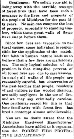

|
~ Cobbs and Mitchell Cadillac and Chandler Township Connections ~
Both Mr. Cobbs and Mr. Mitchell had deep ties with Cadillac MI when they became connected through their Cobbs & Mitchell Railroad Inc. with Chandler Township and their platted Village of Springvale. An OLD book put out by the Michigan Pioneer and Historical Society titled Historic Michigan had biographies and photos of the Cobbs and Mitchell gentlemen whose families were tied to the area.
Title Page

Page 216
|
Jonathan W. Cobbs
|
Page 216
|

Page 232
|
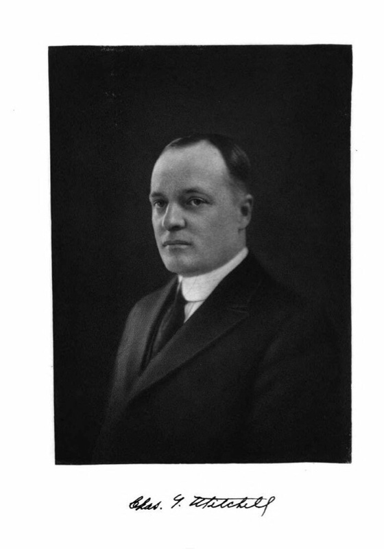
Charles T. Mitchell
|
Page 233
|
Page 234
|
Page 235
|

9 November 1915 ~ Petoskey Evening News
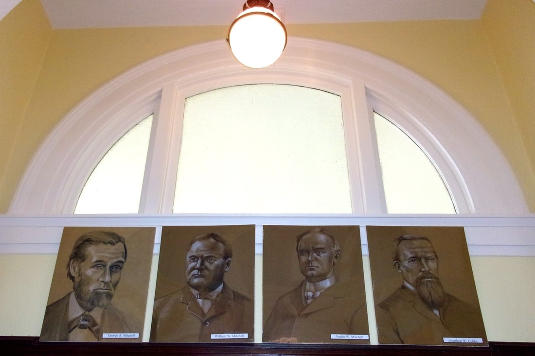
Photo taken 18 July 2015 in Wexford County Historical Society & Museum in Downtown Cadillac MI
Photo Above: Looking upward over the transom of one of the interior main doorways under the dome of the Wexford County Historical Society & Museum, are drawings of L>R: George Mitchell, William W. Mitchell, Austin W. Mitchell, and Jonathon W. Cobbs... all influential men involved in the timber and railroad industries in Cadillac which extended into the forests of Chandler Township near the logging town of Springvale MI. The website of the museum gives any visitor free access to viewing, and downloading full quality photos from their photo gallery... photos which include many, many, "Timber Harvest" photos from the Cadillac area.
The Wexford County Historical Society & Museum has various exhibits set up within its two floors of interesting historical items such as their "School in Session", "Mercantile Store", "History of Photography & Telephone Switchboard", and "Logging" like in the photo below. The exhibit included standard logging items which the lumbermen of Chandler Township also would have used.
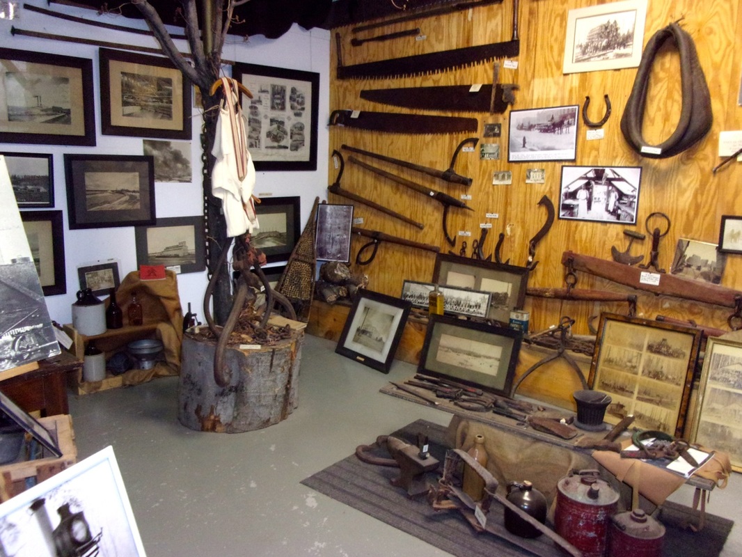
Wexford County Historical Society & Museum Logging Exhibit ~ 18 July 2015
The sign below right for The State of Michigan Historical Site No. 1434 "Charles T. Mitchell House" noted:
"This Prairie style building began as a Second Empire house built by George Mitchell in 1874. A lumberman and Cadillac's first mayor, Mitchell built the house with ornately carved wood-work and a mansard roof. His business partner, Wellington W. Cummer, occupied it from 1878 to 1922, when it was purchased by Mitchell's grandnephew, Charles T. Mitchell. In 1926, Charles, a local industrialist, renovated the house to conform with current architectural trends. Totally redone in the Prairie style and clad with red brick, it lost its ornamentation and gained a low~pitched hipped roof. The extensive renovation was testimony to Charles Mitchell's wealth: his firms employed from one~fourth to one~third of Cadillac's workforce."
"This Prairie style building began as a Second Empire house built by George Mitchell in 1874. A lumberman and Cadillac's first mayor, Mitchell built the house with ornately carved wood-work and a mansard roof. His business partner, Wellington W. Cummer, occupied it from 1878 to 1922, when it was purchased by Mitchell's grandnephew, Charles T. Mitchell. In 1926, Charles, a local industrialist, renovated the house to conform with current architectural trends. Totally redone in the Prairie style and clad with red brick, it lost its ornamentation and gained a low~pitched hipped roof. The extensive renovation was testimony to Charles Mitchell's wealth: his firms employed from one~fourth to one~third of Cadillac's workforce."
Charles T. Mitchell Main House Located on the brick surfaced 200 E. Mason Street Cadillac MI
The Carriage House located to the rear of the main Charles T. Mitchell House
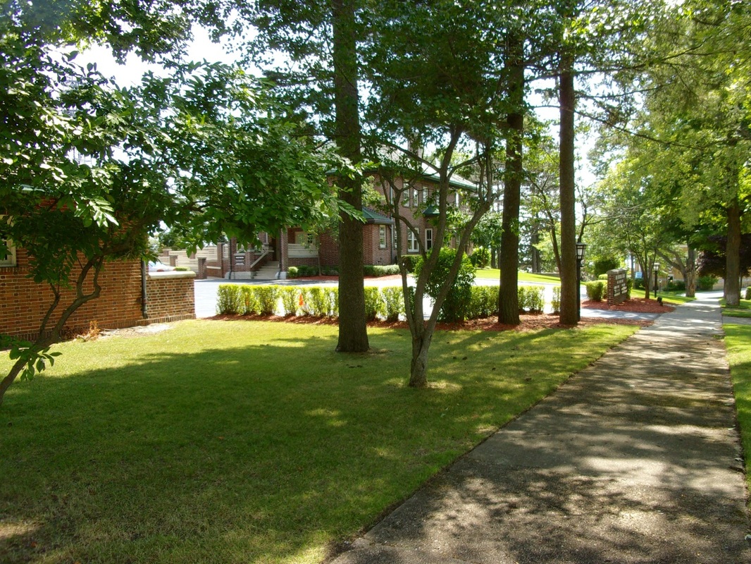
|

Bureau of History, Michigan Department of State Registered Local Site No. 1434
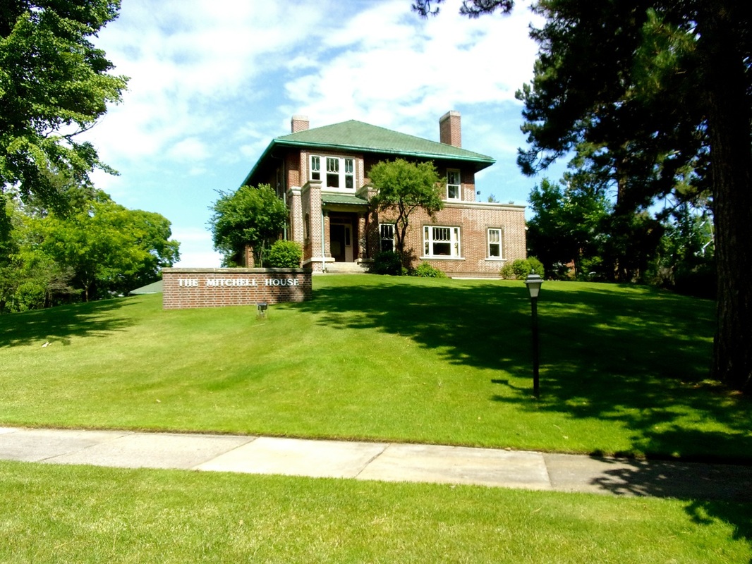
|
