Dot
"A Thriving Community"
In Chandler Township Charlevoix County MI
The design and compilation of the text and photos on this site are copyrighted 2013.
Most posted items will enlarge by "clicking" on them.
"Clicking" on some highlighted words may access additional information.
Please do not copy the photos on this site, many of which have been submitted by private individuals...
just come back and visit the site often to view the photos.
Most posted items will enlarge by "clicking" on them.
"Clicking" on some highlighted words may access additional information.
Please do not copy the photos on this site, many of which have been submitted by private individuals...
just come back and visit the site often to view the photos.
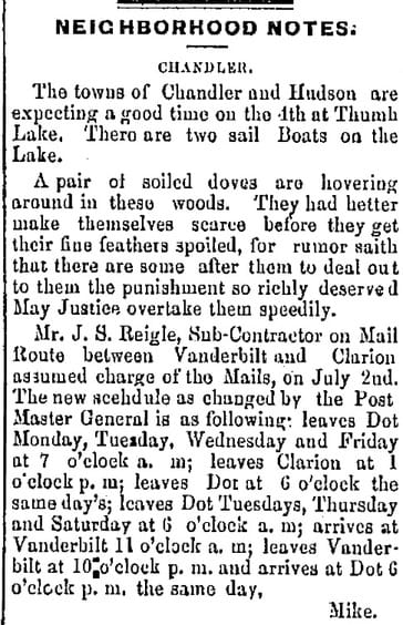
Regarding the location shown on the plat map above in section 24 of the Springvale Post Office, in 1901 that was the location of the home of James Pearson who was the post master and operated the post office from his house... not the location of the Village of Springvale.
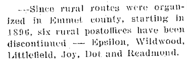
Postal Service was an important asset for Dot.
The rural post office was established on 17 May 1880
with Thomas J. Stradling as the FIRST postmaster.
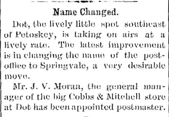
The post office operated until 15 June 1901 when its name changed to Springvale.
Mr. J.V. Moran of Cobbs & Mitchell Store at Dot became the postmaster.
with Thomas J. Stradling as the FIRST postmaster.
The post office operated until 15 June 1901 when its name changed to Springvale.
Mr. J.V. Moran of Cobbs & Mitchell Store at Dot became the postmaster.
4 July 1883 ~ The Petoskey Record newspaper
|
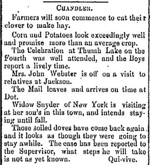
11 July 1883 ~ The Petoskey Record newspaper
|
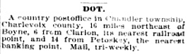
Michigan State Gazetteer and Business Directory 1897 Pub R.L. Polk & Co. Page 722
~~~~~~~~~~~~~~~~~~~~~~~~~~~~~
Click HERE for additional information on this same web site about the Dot Post Office,
and other Chandler Township Post Offices, Post Masters, and Rural Carriers.
~~~~~~~~~~~~~~~~~~~~~~~~~~~~~
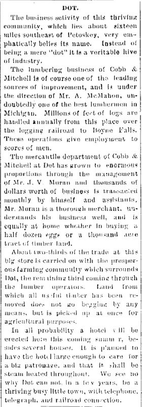
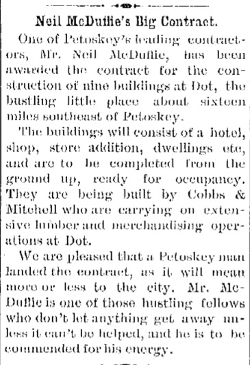
A hustling and bustling village of Dot in Chandler Township was described below
in the 1901 newspaper articles.
3 May 1901 ~ The Independent Democrat
|

12 June 1901 ~ The Petoskey Record
14 June 1901 ~ The Independent Democrat
|
21 June 1901 ~ The Independent Democrat
|
26 June 1885 ~ Emmet County Democrat
21 August 1916 ~ Petoskey Evening News and Daily Resorter
|
~ 1976 ~
Dot is located on State Forest Land.
GPS coordinates for Dot MI
GPS = N45 degrees 16.503 and W84 degrees 47.644.
coordinates submitted by Carl Bajema
GPS coordinates for Dot MI
GPS = N45 degrees 16.503 and W84 degrees 47.644.
coordinates submitted by Carl Bajema
Please do not copy the photos on this site, many of which have been submitted by private individuals...
just come back and visit the site often to view the photos.
just come back and visit the site often to view the photos.
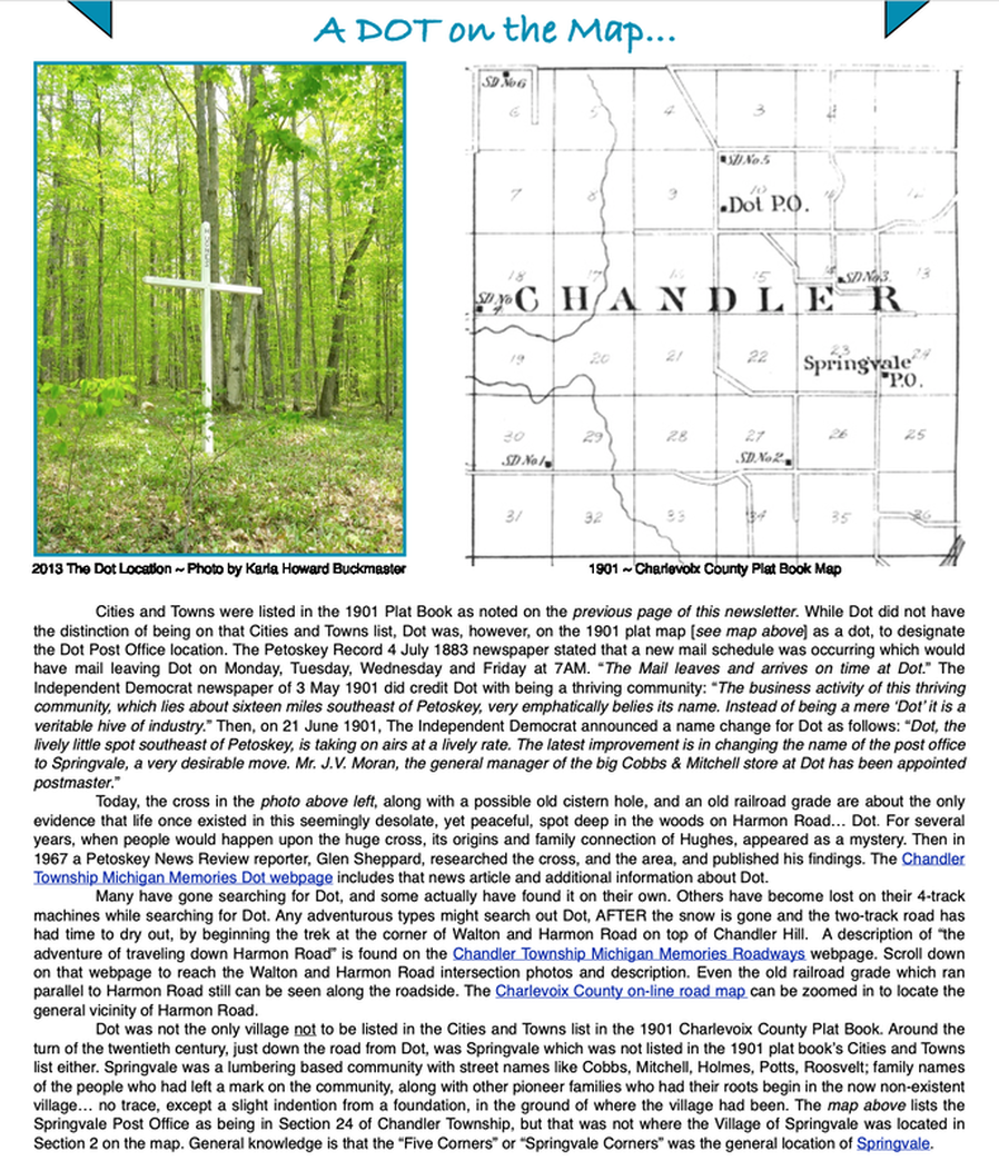
The 1901 plat book map (below) of Chandler Township Charlevoix County pinpoints Dot in section 10.
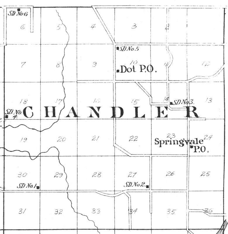
1901 Charlevoix County Plat Book Designation Of Dot P.O.
LIDAR USGS Map Below: Paul Bricker lives in the vicinity of where Dot had been located. Paul enjoys exploring, and researching, the Dot/CCC/Springvale area. He has submitted the LIDAR map below of Dot. LIDAR maps remove all the vegetation from a map and reveal things that are covered by trees and grass. On this map, Harmon Road is north/south. The line running parallel to the road, at the right, next to the hole, is the old railroad grade. LIDAR stands for "Light Detection and Ranging", a remote sensing method that uses light in the form of a pulsed laser to measure ranges (variable distances) to the Earth. LIDAR maps can show old roads, old railroad grades or homestead foundations. LIDAR maps are available on the USGS [United States Geological Survey]web site.


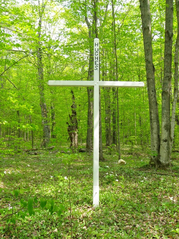
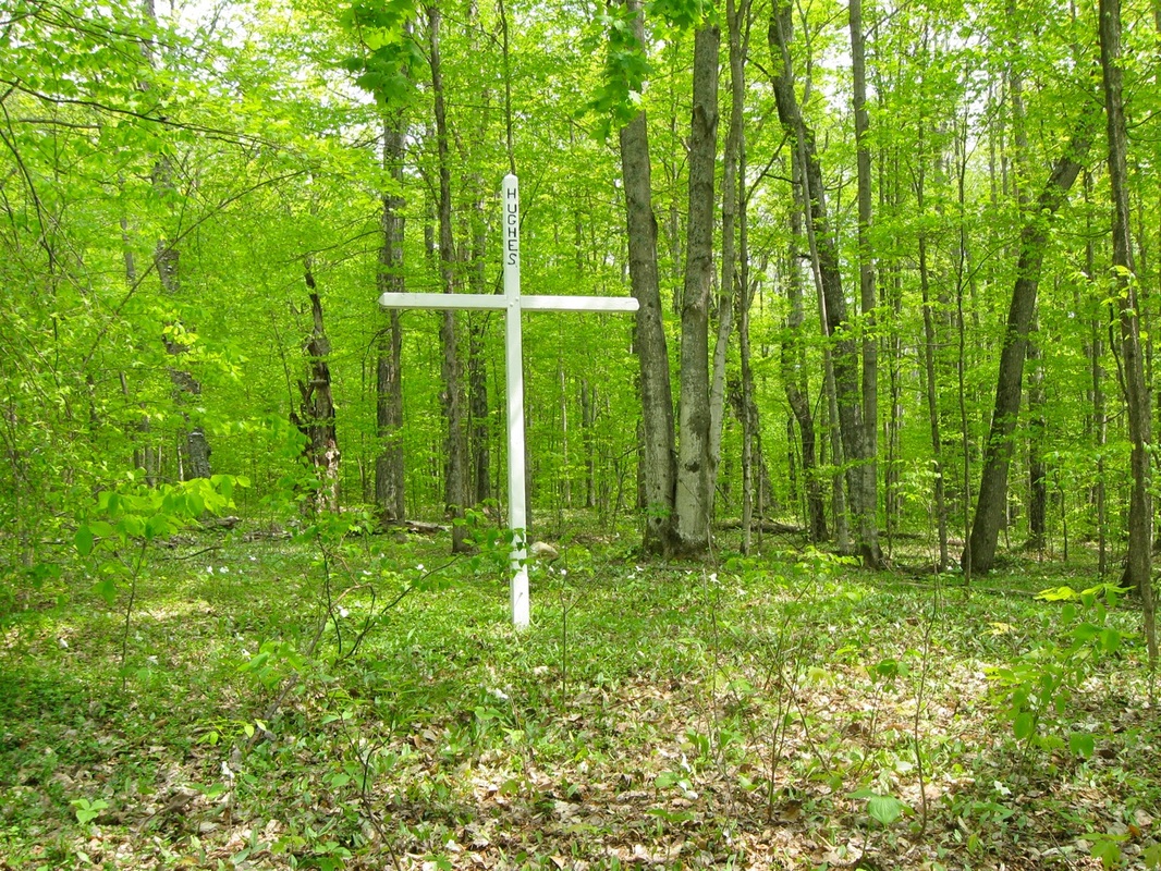
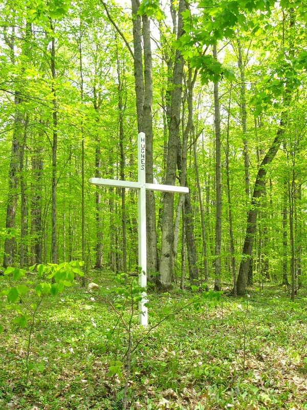
Huge Cross At Dot
Thankfully, in the 12 July 1967 issue of the Petoskey News Review a reporter, Glen Sheppard, included a photograph of a cross [above], and also had researched, and then divulged on page 6, his findings of the “Mystery of Huge Chandler Cross Partially Solved by Reporter”. Otherwise, most knowledge of the existence of Chandler Township’s Dot could have vanished like the Post Office of Dot, the crown on the cross, or the myrtle carpet below the cross. Sadly, someone has stolen the crown from the cross, and at one point, the majestic growth of myrtle below the cross had been sectioned off into squares and stolen away.
Mystery of Huge Chandler Cross
Partially Solved by Reporter
BOYNE FALLS---A massive white cross marks the grave of a man whose first name is unknown in a forest glade of Chandler township that no one owns.
The compound mystery came to light recently when the 10-foot high cross was discovered cemented into the ground in the very northwest corner of section 10 of Chandler township.
Emil Harmon, the nearest private landowner, contacted State Forester Jack Lockwood. State records show the property as being part of the state-owned Jordan River State Forest.
Lockwood took a trip out the forest trail that oldtimers say was known as the “State Road” in pioneer days because the stage coaches between Petoskey and Gaylord ran over it.
Sure enough. There it was. A white-painted cross made of heavy timbers standing 10 foot high with a five foot cross arm and buried in cement.
Near the top is the name “Hughes.” A plain gold-colored head crown is nailed to the cross where the arm joins.
Lockwood doesn’t mind people erecting crosses in the state forest. But he sure was curious.
No one he contacted could explain who Hughes was or why the cross was standing in the open glade deep in the boondocks of Chandler township.
Lockwood knew that many lumber camps and small settlements had disappeared under the second growth forest of Chandler township. The township is the most desolate in Charlevoix county.
Located in the very north-east corner of Charlevoix county--on the Emmet and Cheboygan county lines--Chandler is 80 percent state-owned. Estimates are the 1960 population of 113 has dwindled. Only Peaine township on Beaver Island is smaller in Charlevoix county.
As he tramped around the seemingly indistinctive site he discovered a thick growth of ground myrtle, a three to five inch high green plant. Ground myrtle, his memory recalled, was extensively planted years ago in cemeteries.
Near the trail road he picked up signs of a long-abandoned railroad grade. Further along, he discovered a charred railroad tie.
The State doesn’t pay foresters to research history, so Lockwood called the News-Review.
The county plat book showed the one-acre plot in the very northwest corner of section 10 belonged to a school. Records in the county courthouse were checked.
Register of Deeds files only complicate the mystery and apparently finalized it.
In 1879, the Register’s libers show, the northwest one-quarter (160 acres) of section 10 was the U.S. government. The year before in 1878, Abbey had deeded the one-acre parcel to Springvale School District Number Five.
But the confusion deepens. In 1890 Abbey sold the whole 160 acres--without exempting the one-acre--to Davis Salisbury. In 1899 Salisbury sold the whole 160 to Cobbs and Mitchell, at that time the major timber company in the area.
Cobbs and Mitchell gave the whole business to the State in 1924.
None of these transactions would nullify the 1878 deed to the Springvale school. But there is no Springvale school. So even if the deed were still good there would be no owner.
Perhaps the deed had a reversionary clause in it giving it back to the original owner when it was no longer used for a school. If so it appears that no one will ever know. The county’s records burned in 1887. The deed went up in smoke.
Old county school board records for Chandler township go back to 1919 and show no school on the site.
Orne Fraley, who is a member of the Chandler school board and helped dispose of all school properties in the township when Chandler merged with Walloon Lake in the 1950’s, says there was no deed in the files on the property.
Some of what the official records couldn’t reveal Chandler township pioneer Carl Clark, 86 now of Petoskey could.
Clark recalls that when he came to Chandler township in 1894 there was a school on the site, which is a mile south of the Emmet county line and three miles west of the Cheboygan county line.
There was also a post office called “Dot” and a townhall there, Clark remembers.
He recalls rumors that the school-post office-townhall site had been a cemetery before his time and that most of the graves had been moved before the school was built.
There was a farmer, though, named, he thinks, Sam Hughes who had been buried there but whose grave had not been moved.
The lumber company, Cobbs and Mitchell, later built a railroad through the property, and much of the rest of the township. The school site was used as a siding for the railroad.
A “terrible fire” destroyed the railroad, Clark remembers. He doesn’t recall when, but he does remember seeing the burned rails “when they were bent like corkscrews.”
Clark thought an ancestor of the Hughes family still had property in the township.
Sure enough, a check with Mrs. Joan Blanchard in the tax equalization department turned up a Cecil Hughes of 214 Main-st., Grand Ledge, who owns a summer cottage in the southern end of the township (section 34).
A telephone call to Grand Ledge solved some of the mystery.
After chuckling over the long trail through public records and oldtimers’ memories that led to the him, Cecil Hughes admitted he erected the cross on Memorial Day of this year.
A 67-year-old sheet metal and heating company owner, Hughes said his great grandfather--whose first name he doesn’t know--was supposed to be buried on the site.
“I wanted some marker there so I knew where he was,” Hughes said. He wasn’t concerned about the ownership question. And he had no significant reason for wanting to mark his great grandfather’s grave.
He has no suspicions that his great grandfather deserves special recognition. “I just thought there should be something to show,” he explained.
Cecil Hughes was born in Chandler township and remembers oldtimers talking about the former graveyard and later school, post office and town hall site.
His summer cottage is on Hughes-rd. (named after the pioneer family) about a quarter mile north of Hudson township.
The story about the Dot post office, school and town hall checks out with other oldtimers.
James Finley of Boyne City, retired state forester, remembers there was a decayed log cabin on the site when he first came to the area in 1928. A few living pioneers still talked about the cemetery and post office, but memory of the school had long disappeared by 1928.
The post office was more a horse-changing station for the mail run from Petoskey to Gaylord than it was a local mail station, Finley believes.
Ted McCutcheon, Walloon Lake boat builder, who has a fancy for local lore, also confirms the story.
Cecil Hughes didn’t have in mind the reincarnation of a long faded chapter of local history when he erected the cross. But he has done just that.
Now the unanswered questions remain:
--Who owns the property? (The state will continue to claim ownership until a deed to the contrary is produced.)
--And, what was the first name of the “Hughes” the cross was erected for? Was it Sam? Who was he?
In A. Theodore Halsted's 1997 book Spring-Fed Waters The story of a lake in northern Michigan, on page 65, Halsted quotes Samuel Hughes' GGGGrandson-in-law Doug Waldo telling about how Samuel Hughes had died... Samuel had been working in a logging camp near Dot, became snowbound in camp for two months, when a contagious disease, possibly scarlet fever, took the life of Samuel plus 15 or 20 others. They were buried there in the forest near Dot.
Reprints of Halsted's book, with mention of Dot, can be purchased, or ordered, at local book stores. Spring-Fed Waters The story of a lake in northern Michigan. It also includes many pages about the residents of Chandler Township, and their relationships to Lake Louise/Thumb Lake.
Reprints of Halsted's book, with mention of Dot, can be purchased, or ordered, at local book stores. Spring-Fed Waters The story of a lake in northern Michigan. It also includes many pages about the residents of Chandler Township, and their relationships to Lake Louise/Thumb Lake.

Carl Bajema [L] And Charlie Conn [R] By The Hughes Cross At Dot Location ~ Photo taken by Bruce Gathman 4 May 2001
Carl Bajema of Grand Rapids MI submitted the above photo of himself, and Charlie Conn, taken 4 May 2001 with the Hughes Cross at the location of Dot. Carl has a great interest in the logging railroads, and hiked most of the miles of the Cobbs & Mitchell "Boyne Falls & Northeastern Railroad" from Boyne Falls into the Springvale area. Carl Bajema stated: "A number of logging railroads had corporate names. I found a note that stated that Boyne Falls & Northeastern RR was incorporated in Michigan on May 26, 1899 and dissolution was recorded on May 10, 1937. Corporate names had a number of legal advantages for a logging railroad that built approximately 100 miles of track from Boyne Falls NE in Charlevoix county and all the way into southern Emmet County (Springvale twp) and into western Cheboygan county near Wolverine."
The 1994 article below told: "He [Charlie Conn] plans to expand his collection of historic photographs and continue presenting slide shows, which explore the history of old rail routes and the communities they linked." So, as planned, Charlie Conn was visiting Dot, one of the communities that had been on an old rail route!
The 1994 article below told: "He [Charlie Conn] plans to expand his collection of historic photographs and continue presenting slide shows, which explore the history of old rail routes and the communities they linked." So, as planned, Charlie Conn was visiting Dot, one of the communities that had been on an old rail route!
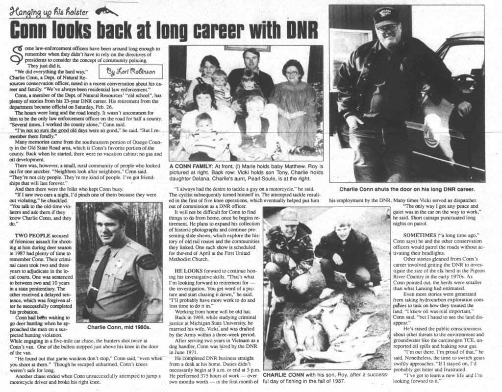
3 March 1994 ~ Gaylord Herald Times
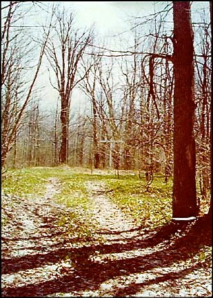
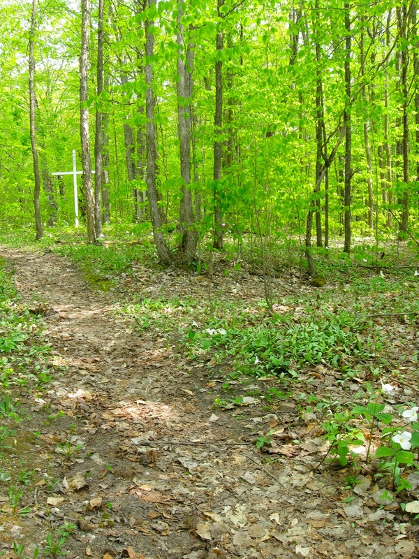
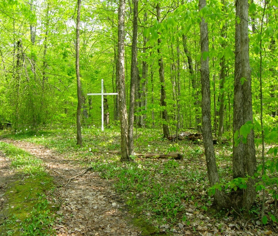
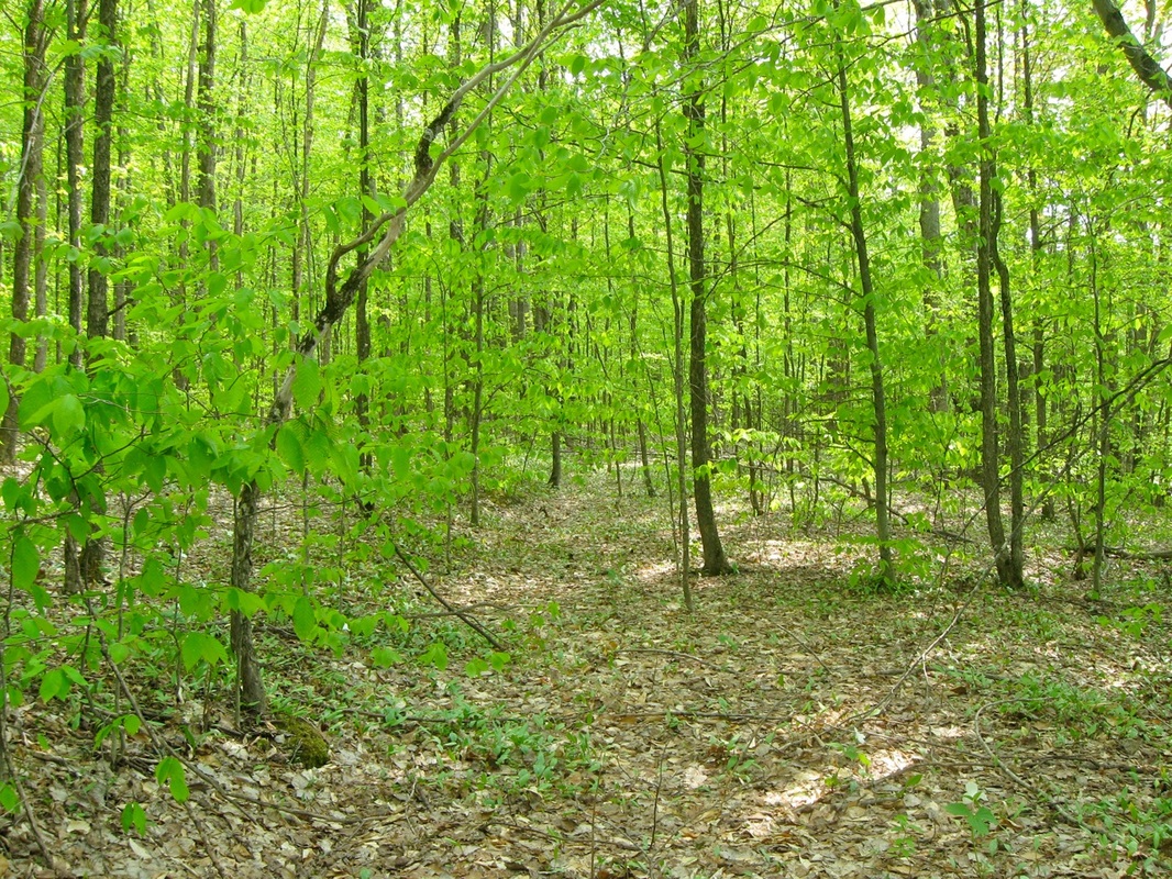
The Hughes Cross at the Dot location was truly a revelation to behold on 19 May 2013... as we were venturing along on Harmon Road, and just quickly came upon the cross in the midst of the woods which were barely awakening to Spring's call, with trilliums scattered below the cross. The roadway seen in the photos below, is not Harmon Road, but rather just a little jut off Harmon Road, up closer to the cross... although the cross was easy enough to spot from Harmon Road itself.
19 May 2013
19 May 2013
|
19 May 2013
19 May 2013
|
19 May 2013
The photo below left provides evidence of an old railroad grade which clearly showed, running parallel to Harmon Road, near to the Hughes cross. Interesting features in the earth, like in the photo below right, surrounding the huge cross and its marking of the location of Dot, revealed this deep hole... maybe an old cistern? Sadly, it has collected litter at the bottom.
19 May 2013
|
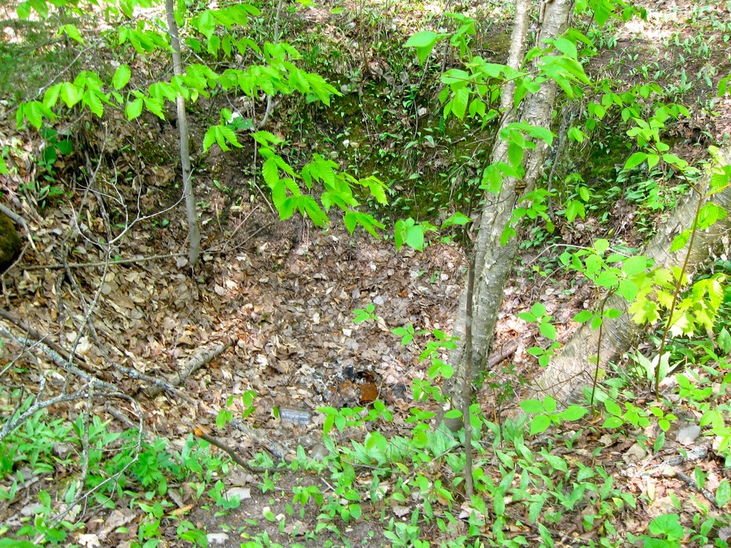
19 May 2013
|
Stories exist that Dot was a "Stagecoach Stop" while the stagecoach was en route from Vanderbilt, Michigan.
The following article from the 20 August 1987 Page 12 Herald Times: Sesquicentennial lends credence to the stagecoach story.
The following article from the 20 August 1987 Page 12 Herald Times: Sesquicentennial lends credence to the stagecoach story.
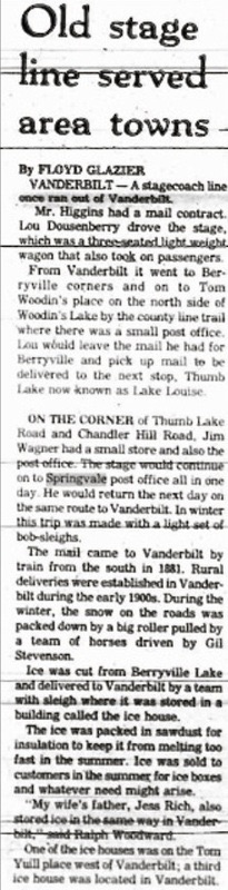
1987 Aug 20 Page 12 Herald Times: Sesquicentennial
Article Below: Undated Petoskey Evening News article tells some history of the Dot area.
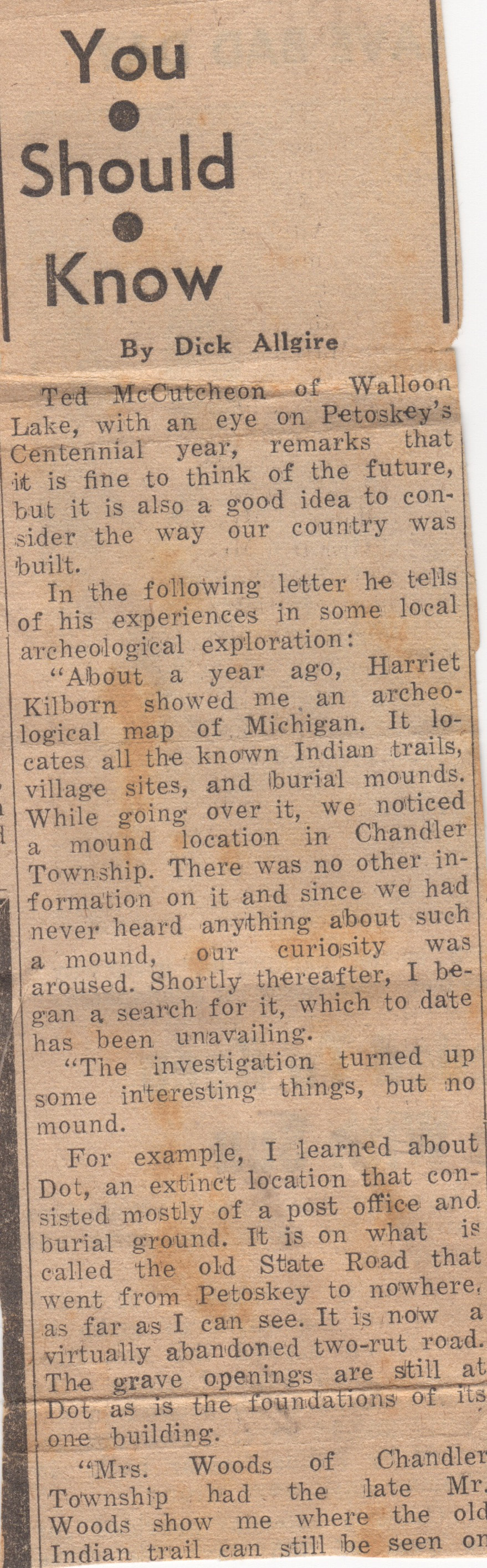
Undated Petoskey Evening News article continued right column...
|
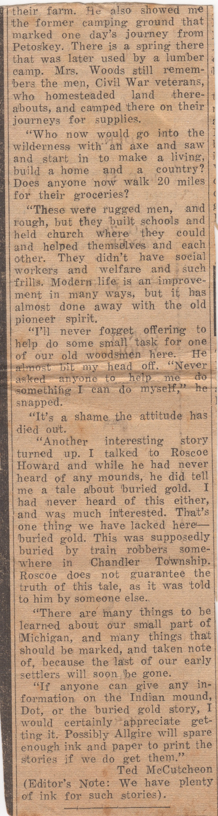
Undated Petoskey Evening News article continued from left column...
|
~ People Known to Have Lived in Dot MI ~
Carl Clark
M.C. and Angeline Miller [Dot MI listed as address for Informant M.C. Miller on the death certificate of Angeline Miller]
M.C. and Angeline Miller [Dot MI listed as address for Informant M.C. Miller on the death certificate of Angeline Miller]
